
Pricing Change
New pricing for orders of material from this site will come into place shortly. Charges for supply of digital images, digitisation on demand, prints and licensing will be altered.
Upcoming Maintenance
Please be advised that this website will undergo scheduled maintenance on the following dates:
Thursday, 9 January: 11:00 AM - 3:00 PM
Thursday, 23 January: 11:00 AM - 3:00 PM
Thursday, 30 January: 11:00 AM - 3:00 PM
During these times, some functionality such as image purchasing may be temporarily unavailable. We apologise for any inconvenience this may cause.
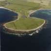
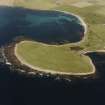
Sanday, Ness Of Brough


Cairn (Prehistoric)(Possible)
Site Name Sanday, Ness Of Brough
Classification Cairn (Prehistoric)(Possible)
Canmore ID 3550
Site Number HY64SE 6
NGR HY 65446 42558
Datum OSGB36 - NGR
Permalink http://canmore.org.uk/site/3550


- Council Orkney Islands
- Parish Cross And Burness
- Former Region Orkney Islands Area
- Former District Orkney
- Former County Orkney
HY64SE 6 6544 4256.
At HY 6544 4256 are the remains of a turf-covered mound of stones, probably a cairn, measuring c10.0m in diameter by c0.4m high. Its NW arc is eroded by the sea exposing closely packed stones.
Surveyed at 1/2500.
Visited by OS (AA)
'The Orcadian' in 1907 describes finds from a "picts house" or broch.
M Howe 2006
Field Visit (August 1979)
As described an unsubstantial cairn gradually succumbing to
sea erosion.
Information from Orkney SMR (RGL) Aug 79.
Note (1980)
Ness of Brough, Sanday, HY 6544 4256 HY64SE 6
An insubstantial cairn of close-packed stones being gradually eroded by the sea.
RCAHMS 1980
(OR 264)
Field Visit (23 September 1993)
This cairn was visited during the Orkney Barrows Project. It measures 9.0m in diameter and 0.5m in height. Some angular rubble was noted. It is prominent from the S inland against the sea for 500m.
Information from the Orkney Barrows Project (JD), 1993
Field Visit (1999)
A stony, sub-oval mound lies on the coast edge and is being eroded by the sea. Aligned east-west, it measures 11m by 6m and stands up to 0.75m high. The surface is uneven and there are occasional earthfast stones protruding through the turf. The coastal section reveals three layers of horizontally-banded stones in a loamy matrix. There are several other, more slight, rises in this area, which are being eroded by the sea. It is difficult, however, to determine archaeological deposits from the mass of storm-cast material in the section. Ref.: RCAHMS (1980), #12.
Coastal Zone Assessment Survey, 1999

