
Pricing Change
New pricing for orders of material from this site will come into place shortly. Charges for supply of digital images, digitisation on demand, prints and licensing will be altered.
Chapelton


Unenclosed Settlement (Prehistoric)
Site Name Chapelton
Classification Unenclosed Settlement (Prehistoric)
Canmore ID 35479
Site Number NO64NW 44
NGR NO 6215 4835
Datum OSGB36 - NGR
Permalink http://canmore.org.uk/site/35479


- Council Angus
- Parish Inverkeilor
- Former Region Tayside
- Former District Angus
- Former County Angus
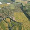
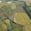
NO64NW 44 6215 4835.
NO 621 483. Settlement (Site), Chapelton: In a field S of Boysack an extensive complex of crop-marks has been recorded which probably represents an unenclosed settlement. Some of the circular marks almost certainly represent the sites of houses measuring about 10m in diameter, and there are also several small marks which are apparently rectlinear.
RCAHMS 1978
Information to follow.
RCAHMS (KJ) 6 April 2000.
Field Visit (March 1978)
Chapelton NO 621 483 NO64NW
In a field S of Boysack an extensive complex of crop-marks has been recorded which probably represents an unenclosed settlement. Some of the circular marks almost certainly represent the sites of houses measuring about 1Om in diameter, and there are also several small marks which are apparently rectilinear.
RCAHMS 1978, visited March 1978
Aerial Photographic Transcription (23 February 1992 - 6 March 1992)
An aerial transcription was produced from oblique aerial photographs. Information from Historic Environment Scotland (BM) 31 March 2017.

