
Easdale, Building


Industrial Building (19th Century) - (20th Century), Powder Magazine (Period Unassigned)(Possible)
Site Name Easdale, Building
Classification Industrial Building (19th Century) - (20th Century), Powder Magazine (Period Unassigned)(Possible)
Canmore ID 354783
Site Number NM71NW 136
NGR NM 73629 17079
Datum OSGB36 - NGR
Permalink http://canmore.org.uk/site/354783


- Council Argyll And Bute
- Parish Kilbrandon And Kilchattan
- Former Region Strathclyde
- Former District Argyll And Bute
- Former County Argyll
Desk Based Assessment (September 2015)
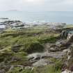
This slate built roofless building is not depicted either on the 1st edition of the Ordnance Survey 25-inch map (Argyllshire and Buteshire, (surveyed 1871) published 1872, sheet CXXI.7) nor on the 2nd edition of the Ordnance Survey 25-inch map (Argyllshire, 1898, sheet CXXI.7). It is situated close to quarry NM71NW 120 (known as Klondyke) which was opened up after 1871 abd by 1898. The building measures 4.0m by 3.5m overall. Its size and location suggests that it is a magazine to store explosives.
Visited by HES Survey and Recording Section, Architecture and Industry (MMD), 8 September 2015.

