
Easdale, Enclosure


Enclosure (19th Century) - (20th Century), Industrial Building (19th Century) - (20th Century)
Site Name Easdale, Enclosure
Classification Enclosure (19th Century) - (20th Century), Industrial Building (19th Century) - (20th Century)
Canmore ID 354782
Site Number NM71NW 135
NGR NM 73477 17080
Datum OSGB36 - NGR
Permalink http://canmore.org.uk/site/354782


- Council Argyll And Bute
- Parish Kilbrandon And Kilchattan
- Former Region Strathclyde
- Former District Argyll And Bute
- Former County Argyll
Note (1994)
WIthall notes that this unroofed structure is on the site of a probable locomotive shed shown on 'the 1896 map' [2nd edition of the Ordnance Survey 25-inch map (Argyllshire, 1898, sheet CXXI)]. The current structure is of poor build leading Withall to suggest that it has been built from the material of original building. He suggests that it was converted into a garden and that the vegetaion inside the enclosed area which is more abundant than outwith its walls supports this theory.
National Record of the Historic Environment: MS8087/2
Field Visit (8 September 2015)
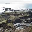
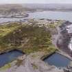
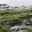
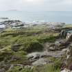
This slate built enclosure (probably a garden) is in a ruinous state. The enclosure measures 14.5m in length by 9.0m in width and contains wild vegetation.
It does not appear on the 1st edition of the Ordnance Survey 25-inch map (Argyllshire and Buteshire, (surveyed 1871) published 1872, sheet CXXI.7) which shows a large area of garden plots. The remains of the earlier gardens would have been overlain by waste or destroyed when quarry NM71NW 117 was extended after 1871.
The enclosure does not appear on the 2nd edition of the Ordnance Survey 25-inch map (Argyllshire, 1898, sheet CXXI.7) and so probably post dates the abandonment of quarries NM71NW 116 and 117. It overlies the tramway shown on the 1898 map.
Visited by HES Survey and Recording Section, Architecture and Industry (MMD), 8 September 2015.

