
Easdale, Building


Industrial Building (19th Century) - (20th Century)
Site Name Easdale, Building
Classification Industrial Building (19th Century) - (20th Century)
Alternative Name(s) The Forge; A'cheardach
Canmore ID 354779
Site Number NM71NW 132
NGR NM 73553 17194
Datum OSGB36 - NGR
Permalink http://canmore.org.uk/site/354779


- Council Argyll And Bute
- Parish Kilbrandon And Kilchattan
- Former Region Strathclyde
- Former District Argyll And Bute
- Former County Argyll
Note (1994)
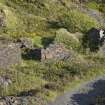
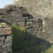
According to PW F Whitall, this building is locally known as 'The Forge' (1994) and as 'A'Cheardach' - the Smithy - in the late 1890s (from a map drawn in 1974 by 'J. Adams', see MS8087/1/4). It is ruinous and has two compartments, one of which was probably used as the smithy.
Horses were in use on Easdale until locomotives were introduced (1860s) to move the slate along the tramways (introduced in the 1830s). It may be that the name change happened when this change from manual and horse power moved to steam.
The remains of the hearth and fires were visible when Withall carried out a survey of the building remains 1989.
Information from National Record of the Historic Environment manuscript: MS8087/1
Field Visit (2016)
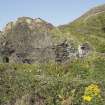
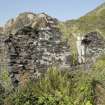
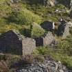
This rubble built building, referred to locally as the Forge, was roofless on the date of visit. It is built of slate with 'snecking' (use of smaller slate infill stones) in place of mortar and has some dressed quoins at openings. Later repairs using mortar were identified by Withall (MS8087/1) and could be seen in the north elevation along with a blocked doorway on the date of visit (see DP228066). Each compartment had a opening on the west elevation and a splayed window in the south elevation. The building would have been single storey.
It measures 14.2m in overall length and consists of two compartments. The south compartment measures 9.7m in overall length (8.25m internally) by 6.78m in overall width (4.75m internally). The east wall measures 0.6m in width and the north, west and south walls measure 0.5m in width.
The buildings contains the remains of a hearth with two openings and part of the chimney breast. The hearth would have been where metal was heated to enable the smithy to repair tools and other damaged metalwork. The smithy or blacksmith may also have made implements required by the quarry workers. The height of the chimney was not ascertained due to the dangerous state of the remains. The second compartment at the north end of the building was probably the fuel store. This measures 6.0m in length by 4.22m in width overall.
The building has deteriorated since Withall's survey in 1989 (see MS 8087/1 and DP228065-66).
The building is shown as roofed but unnamed on the 2nd edition Ordnance Survey 25-inch map (Argyllshire, 1898, sheet CXXI.7). It is still presumably in use by 1898. It may have been associated with quarry NM71NW 117 and quarry NM71NW 116 and the buildings NM71NW133 (The Engine House) and 134 (The Boiler House) which are shown as roofed in 1898.
See National Record for the Historic Environment: MS/8087/1
Visited by HES, Survey and Recording, (M McDonald), September 2016.

