
Easdale, Coal Store


Coal Store (20th Century)(Possible)
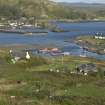
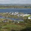
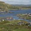
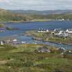
Site Name Easdale, Coal Store
Classification Coal Store (20th Century)(Possible)
Alternative Name(s) Coalery; Coalry
Canmore ID 354774
Site Number NM71NW 130
NGR NM 73825 17101
Datum OSGB36 - NGR
Permalink http://canmore.org.uk/site/354774


- Council Argyll And Bute
- Parish Kilbrandon And Kilchattan
- Former Region Strathclyde
- Former District Argyll And Bute
- Former County Argyll
Note (1994)
According to PW F Whitall, this building is locally known as 'The Coalery' (1994). It is the only building associated with the island quarries (apart from the worker's housing in Easdale village) that is still in use. It is similar in style and character to The Forge and The Engine House (NM71NW 132 and NM71NW 133). It is noted that 'the 1896 map' (see NMS/8087/4 - annotated map based on the 2nd edition Ordnance Survey map (Argyllshire, revised 1898, published 1899, sheet CXXI.11)] shows tramway rails entering the building. This suggests that it was a locomotive shed. It is also noted that wooden sleepers survived in 1994. An upper floor or hay loft suggests that it was used as horse stabling, perhaps prior to the introduction of locomotives to haul quarry bogeys or wagons in the 1860s. Withall suggests that the building dates from sometime in the 1830s (when horse-drawn tramways were introduced) to the 1880s (after which locomotives were no longer in use by the quarries).
The name 'Coalery' or 'Coalry' seems to post-date its association with quarrying.
Information from National Record of the Historic Environment manuscript: MS8087/1
Field Visit (9 September 2015)
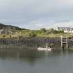
This slate-built and slate-roofed building is still in use. The building measures 12.68m in length by 9.63m in width overall. The lower pitched north bay may be later than the south bay - there is a straight joint visible in the east elevation. The hayloft taking-in door can be seen on the south elevation, suggesting perhaps food storage for horses. The lean-to on the north west corner of the building is a later addition.
Any evidence of the bulding's tramway association as shown on the 2nd edition Ordnance Survey map (Argyllshire, revised 1898, published 1899, sheet CXXI.11) is now gone. The former tramway bed is now a pathway.
It was not possible to access the interior on the date of visit to see if the three wooden sleepers observed by Withall in 1994 were still in situ.
See National Record for the Historic Environment: MS/8087/1
Visited by HES, Survey and Recording, (M McDonald), 9 September 2016.
Desk Based Assessment (January 2019)
This building, which is associated with quarries NM71NW 114-118, is depicted as roofed on the 2nd edition of the Ordnance Survey 25-inch map (Argyllshire, revised 1898, published 1899, sheet CXXI.7). Tramway rails are shown entring the building indicating that by before 1898 it was used, perhaps, as a locomotive shed. It is also depicted on the 1st edition Ordnance Survey map (Argyllshire and Buteshire, revised 1871, published 1872, sheet CXXI.11) but no tramway rails are depicted. The building is two storey and the upper floor may have been a hayloft. It is a possibility that it was used as stabling for tramway horses prior to the introduction of steam engines.
Withall (MS/8087/1) notes that the J. Adams, 1974 map (annotated version, based on the 2nd edition 25-inch Ordnance Survey map, Argyllshire, 1898, sheet CXXI.7, see MS/8087/4) annotates this building as 'being adjacent to the Ceidh an Stabuill (the Stable Quarry).
Information from HES Heritage Directorate, Survey and Recording Section, (MMD) 31 January 2019.

