Accessibility

Font Size

100% 150% 200%

Background Colour

Default Contrast
Close Reset

Easdale, Building

Powder Magazine (19th Century)(Possible)

Site Name Easdale, Building

Classification Powder Magazine (19th Century)(Possible)

Alternative Name(s) Tigh An Fhudair

Canmore ID 354773

Site Number NM71NW 131

NGR NM 73651 17243

Datum OSGB36 - NGR

Permalink http://canmore.org.uk/site/354773

Ordnance Survey licence number AC0000807262. All rights reserved.
Canmore Disclaimer. © Bluesky International Limited 2025. Public Sector Viewing Terms

Toggle Aerial | View on large map

Digital Images

Quarry buildings, general view from break in wall to east
Quarry buildings, general view from break in wall to eastQuarry buildings, view from break in wall to eastCreag Nam Duin Quarry (NM71NW 115), view from northCreag Nam Duin Quarry (NM71NW 115), general view from northMagazine, machine plinth, part of retaining wall of quarry NM71NW 115 view from north eastQuarry building and south east wall of Causeway (former tramway) between Creag Na H-Uamha quarry (NM71NW 114), view from high ground to south westQuarry (NM71NW 114), spoil at south end (around NM73713 17307), view from north eastOblique aerial viewNorth gardens, remains of building, view from northCauseway between the quarries known as Creag Na H-Uamha (NM71NW 114) and Creag Nam Duin (NM71NW 115), view from north westNorth gardens, tramway, quarry buildings beyond, view from eastNorth gardens, quarry buildings, general view from north eastQuarry building, view from eastCauseway and  Creag Nam Duin quarry (NM71NW 115), view from westCauseway and Creag Nam Duin quarry (NM71NW 115), general view from westQuarry building and south east wall of Causeway (former tramway) between Creag Na H-Uamha quarry (NM71NW 114), view from high ground to south westNorth gardens, quarry building, view from northNorth gardens, break in wall and quarry building, view from causeway between quarries nos. 3 and 4 to north westCauseway between Creag Na H-Uamha Quarry (NM71NW 114) and Creag Nam Duin Quarry (NM71NW 115) and quarry building, view from north westNorth gardens, quarry building, view from northQuarry building and Causeway (former tramway) between Creag Na H-Uamha quarry (NM71NW 114), view from high ground to southOblique aerial view from east of Hill Quarry, Windmill Hill, tramway bed and the former powder magazine and remnants of engine house in the foreground.North gardens, remains of building, view from north eastRemains of quarry-related machine plinth structure, view from south with Creag Na H-Uamha Quarry (NM71NW 114) in backgroundCauseway between Creag Na H-Uamha Quarry (NM71NW 114) and Creag Nam Duin Quarry (NM71NW 115), view from north westOblique aerial view showing Windmill (flooded, right) and Hill Quarry (FLOODED, LEFT), west end of Doune Quarry (left) and the 'fingers' of the tipping (foreground) from the reworking of Hill Quarry in the early 20th century.Creag Na H-Uamha Quarry (NM71NW 114), general view from westTrack cutting through spoil with quarry building beyond, view from eastOblique aerial view from west showing original tramway, post-1899 tramway, and the landscape towards the Village.

Administrative Areas

  • Council Argyll And Bute
  • Parish Kilbrandon And Kilchattan
  • Former Region Strathclyde
  • Former District Argyll And Bute
  • Former County Argyll

Activities

Field Visit (9 September 2015)

NM71NW 131.00. See also NM71NW 131.01

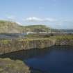
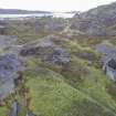
This is a roofless, rubble built building measuring 3.19m by 2.68m internally. Tucker (1976) translates the Gaelic name for the building, Tigh an Fhudair, as powder house or magazine.

This building's earliest map depiction is as roofed but not named on the 2nd edition of the Ordnance Survey 25-inch map (Argyllshire, 1898, sheet CXXI.7). There is evidence that the rear wall of this small building continues west beyond its west gable indicating that the wall is probably associated with the earlier, larger engine house which stood on the site ( It occupies part of the site of an engine house depicted and named on the 1st edition of the Ordnance Survey 25-inch map (Argyllshire and Buteshire, surveyed 1871, published 1872, sheet CXXI.7). See NM71NW 131.01.

G Tucker, 1976

Visited by HES (Survey and Recording), MMcDonald, 9 September 2015.

Note

This slate-built, mortared, single storey building would have been used to store black powder used in quarrying operations. The building is a single chambered structure although Withall notes that it has 'been stated that the resent single chamber was orignally divided by a partition to form two areas' but that the partition no longer existed on the date of his visit (1994).

Information from National Record of the Historic Environment manuscript: MS8087/1

References

MyCanmore Image Contributions


Contribute an Image

MyCanmore Text Contributions