
Following the launch of trove.scot in February 2025 we are now planning the retiral of some of our webservices. Canmore will be switched off on 24th June 2025. Information about the closure can be found on the HES website: Retiral of HES web services | Historic Environment Scotland
Prail Castle


Promontory Fort (Iron Age)
Site Name Prail Castle
Classification Promontory Fort (Iron Age)
Canmore ID 35438
Site Number NO64NE 7
NGR NO 6972 4643
Datum OSGB36 - NGR
Permalink http://canmore.org.uk/site/35438


- Council Angus
- Parish Inverkeilor
- Former Region Tayside
- Former District Angus
- Former County Angus
NO64NE 7 6972 4643.
(NO 6972 4643) Prail Castle (NAT) Fort (NR)
OS 6" map (1970)
The fortifications of a castle known as Cuithal or Prile Castle lie on Caircock Head. The ditch, rampart and the foundation of the tower and other buildings are visible.
J Carrie 1881; G Cumming 1843
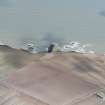
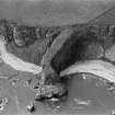
The few earthworks that exist here seem to be the remains of a promontory fort. A long, narrow promontory bounded on three sides by precipitous cliffs, forms the main enclosure. At its W end is a short rocky scarp 2.5m high, on the crest of which is a mutilated bank on 0.3m high on the N and 1.0m high on the S, running to the cliff edge on either side. A causeway 3.0m wide and 0.3m high runs from the foot of this scarp to a rampart 12.0m distant. This rampart is 1.0m high and 3.0m broad, rising to 3.0m at the southern cliff edge, making use of a natural ridge as it rises. The course of the northern part of this rampart is uncertain.
A natural hollow 6.0m wide SW of this leads to another rampart 2.0m high at its S end and 1.0m high towardss its northern limit. It is 4.0m - 6.0m broad. The northern part of this bank has been destroyed. At a point c.14.0m N of the causeway and at the cliff edge is what may be a fragment of bank 6.0m long and 1.0m high - possibly the end of the medial bank.
A disturbed area c. 20.0m x 18.0m, E of the innermost rampart may denote the sites of buildings as mentioned by Cumming, but nothing definite can be made out. Two rectangular hollows, each 8.0m x 5.0m, at the extreme end of the promontory, are simply the site of a wartime Home Guard post.
Visited by OS (JLD) 10 June 1958
The remains of this promontory fort are generally as described. The headland is known locally as "Prail Castle".
Surveyed at 1:2500.
Visited by OS (JTT) 20 October 1965
Field Visit (March 1978)
Prail Castle NO 697 464 NO64NE 7
This coastal promontory fort is defended by three ramparts.
RCAHMS 1978, visited March 1978
(Cumming 1843, 110-11; Carrie 1881, 11)
Note (3 June 2015 - 18 May 2016)
This promontory fort is situated on the cliffs NE of West Mains. A narrow finger of land girt with precipices along its flanks, the seaward end evidently spans a natural arch, while continuing erosion in a narrow crevice on the S side has constricted the neck still further. At the top of this crevice a rocky scarp cuts across the neck of the promontory and is crowned by the remains of the inner rampart, which varies between 0.3m in height at the cliff edge on the N to 1m on the S. The outer defences are disposed to either side of a central entrance causeway approaching from the W, two ditches with a medial rampart lying to the N and three ditches with intermediate ramparts on the S. The ditches are probably adapted from natural gullies, the broadest measuring some 6m across, while the ramparts are from 3m to 6m in thickness and stand between 1m and 3m high above the bottoms of the ditches. The interior measures a maximum of 110m in length from ESE to WNW by a maximum of 21m transversely, and though traces of buildings were reported here in 1843 (Cummings 1843), possibly on the assumption that this is the site of a medieval castle, they are not in evidence today, and the only features that are visible are the remains of a Home Guard lookout post at the extreme E tip of the promontory; this has been reduced to two rectangular hollows, each measuring about 8m in length by 5m in breadth.
Information from An Atlas of Hillforts of Great Britain and Ireland – 18 May 2016. Atlas of Hillforts SC3092

