Accessibility

Font Size

100% 150% 200%

Background Colour

Default Contrast
Close Reset

Newbarns

Barrow (Prehistoric)(Possible)

Site Name Newbarns

Classification Barrow (Prehistoric)(Possible)

Canmore ID 35431

Site Number NO64NE 50

NGR NO 68457 49177

Datum OSGB36 - NGR

Permalink http://canmore.org.uk/site/35431

Ordnance Survey licence number AC0000807262. All rights reserved.
Canmore Disclaimer. © Bluesky International Limited 2025. Public Sector Viewing Terms

Toggle Aerial | View on large map

Digital Images

Oblique aerial view of Newbarns
Oblique aerial view of NewbarnsOblique aerial view of Newbarns.General oblique aerial view of the cropmarks of the enclosures, taken from the SE.General oblique aerial view of the cropmarks of the enclosures, taken from the NE.Newbarns, oblique aerial view, taken from the NE, centred on cropmarks including those of two rectilinear enclosures and several ring-ditches.Oblique aerial view.Oblique aerial view.Oblique aerial view centred on the cropmarks of the unenclosed settlement, souterrain, ring ditches, enclosures, linear features and pits at Newbarns, looking to the NE.Newbarns, oblique aerial view, taken from the NNW, centred on cropmarks including those of two rectilinear enclosures and several ring-ditches.Newbarns, oblique aerial view, taken from the ESE, centred on cropmarks including those of two rectilinear enclosures and several ring-ditches.Oblique aerial view centred on the cropmarks of the enclosures, souterrains, barrows, ring ditches, linear features and pits at Newbarns, looking to the NW.Oblique aerial view centred on the cropmarks of the unenclosed settlement, rectilinear enclosures, souterrains, barrows, ring ditches, linear features and pits at Newbarns, looking to the S.Oblique aerial view centred on the cropmarks of the unenclosed settlement, ring ditches, souterrains, enclosure, linear features, rig and pits at Newbarns, looking to the WSW.Oblique aerial view of the cropmarks of the enclosures, taken from the SW.General oblique aerial view of the cropmarks of the enclosures, taken from the E.Oblique aerial view.Oblique aerial view.Oblique aerial view centred on the cropmarks of the enclosures, souterrains, barrows, ring ditches, linear features and pits at Newbarns, looking to the NNW.Oblique aerial view of Newbarns.Oblique aerial view.Oblique aerial view.Oblique aerial photograph
Newbarns, NO64NE 50, Ordnance Survey index card, RectoOblique aerial view.Oblique aerial view.Oblique aerial view.Oblique aerial view.Oblique aerial view centred on the cropmarks of the unenclosed settlement, rectilinear enclosures, souterrains, barrows, ring ditches, linear features and pits at Newbarns, looking to the N.Oblique aerial view.Oblique aerial view.Oblique aerial photograph
Oblique aerial view centred on the cropmarks of the unenclosed settlement, rectilinear enclosures, souterrains, barrows, ring ditches, linear features and pits at Newbarns, looking to the NNE.Oblique aerial view centred on the cropmarks of the unenclosed settlement, rectilinear enclosures, souterrains, barrows, ring ditches, linear features and pits at Newbarns, looking to theOblique aerial viewof Newbarns.Oblique aerial view of the cropmarks of the enclosures, taken from the WSW.Oblique aerial view.Oblique aerial view.Oblique aerial view.Oblique aerial view.Oblique aerial view.Oblique aerial photograph
Newbarns, NO64NE 50, Ordnance Survey index card, RectoOblique aerial view centred on the cropmarks of the enclosures, souterrains, barrows, ring ditches, linear features and pits at Newbarns, looking to the NE.Oblique aerial view of the cropmarks of the enclosures, taken from the SSW.Oblique aerial view.

Administrative Areas

  • Council Angus
  • Parish Inverkeilor
  • Former Region Tayside
  • Former District Angus
  • Former County Angus

Archaeology Notes

NO64NE 50 NO 68457 49177

Activities

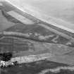
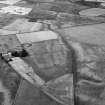
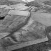
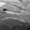
Aerial Photographic Transcription (24 February 1994 - 21 April 1994)

An aerial transcription was produced from oblique aerial photographs. Information from Historic Environment Scotland (BM) 31 March 2017.

References

MyCanmore Image Contributions


Contribute an Image

MyCanmore Text Contributions