
Newbarns Smithy


Cropmark(S) (Period Unknown), Enclosure(S) (Period Unknown), Field System (Period Unknown), Pit(S) (Period Unknown)
Site Name Newbarns Smithy
Classification Cropmark(S) (Period Unknown), Enclosure(S) (Period Unknown), Field System (Period Unknown), Pit(S) (Period Unknown)
Canmore ID 35403
Site Number NO64NE 26
NGR NO 68102 49202
NGR Description Centred on NO 68102 49202
Datum OSGB36 - NGR
Permalink http://canmore.org.uk/site/35403


- Council Angus
- Parish Inverkeilor
- Former Region Tayside
- Former District Angus
- Former County Angus
Note (1978)
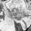
New Barns Smithy NO 676 491 NO64NE
A group of crop-marks have been recorded W of New Barns Smithy. One circular mark may indicate the site of a house measuring about 10m in diameter, and there are probably two others. There are also at least three square enclosures, which measure on average about 10m across, and a number of other indeterminate marks.
RCAHMS 1978
Aerial Photographic Transcription (24 February 1994 - 21 April 1994)
An aerial transcription was produced from oblique aerial photographs. Information from Historic Environment Scotland (BM) 31 March 2017.

