
Easdale, South West Spoil, Walls And Workings


Industrial Landscape (Period Unassigned)
Site Name Easdale, South West Spoil, Walls And Workings
Classification Industrial Landscape (Period Unassigned)
Alternative Name(s) Camas Mor
Canmore ID 354003
Site Number NM71NW 125
NGR NM 73591 17035
NGR Description centred on NM 73591 17035
Datum OSGB36 - NGR
Permalink http://canmore.org.uk/site/354003


- Council Argyll And Bute
- Parish Kilbrandon And Kilchattan
- Former Region Strathclyde
- Former District Argyll And Bute
- Former County Argyll
Desk Based Assessment (15 February 2019)
NM71NW 125
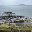
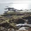
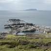
A field survey was carried out of the west, north and east portions of Easdale Island by HES on visits over the period 2015-2017. The island was split into sections in order to deal with the complex re-mains in this ever changing, quarried landscape.
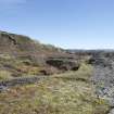
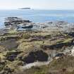
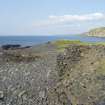
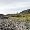
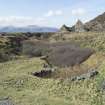
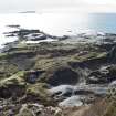
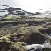
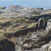
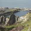
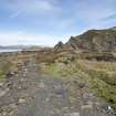
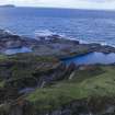
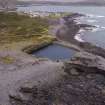
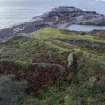
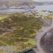
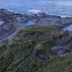
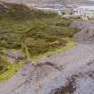
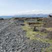
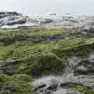
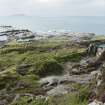
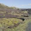
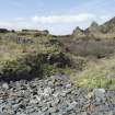
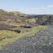
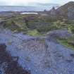
This area (NM71NW 125) known as south west spoil, walls and workings (for the requirements of the survey), is bounded by the sea to the south and the west, Fang Quarry NM71NW 118 to the south west and the quarries An lub chlear and An toll mor Thicath (NM71NW 116 and NM71NE 117) to the north.
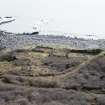
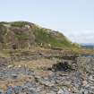
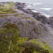
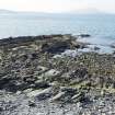
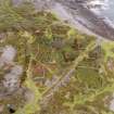
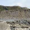
This area contains the remains of south west grouping of garden enclosures that have been quarried away on the extreme west edge (due to the opening of quarries NM71NW 117 and 118 and based on quarry proximity), as well as slate waste clearly visible on the 1946 aerial photograph (NCAP_SCOT_106G_SCOT_UK_0049_4267, 4th May 1946) centred at NM73458 17039 (derived partly from the opening up of quarries NM71NW 117, 116 and 118) and NM73587 16976 (derived partly from coastal quarrying and latterly NM71NW 120 (Klondyke Quarry).
Information from HES, Survey and Recording Section, (MMD) 15 February 2019.
Note (22 February 2019)
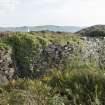
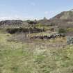
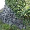
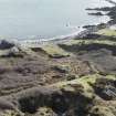
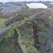
The garden enclosures on Easdale were created by the inhabitants to enable the growing of food from the 18th century on. The soil from the enclosures is said to have come from Ireland as ballast on the return journeys of slate cargo boats. Food supplies would have arrived on the island by boat but fresh food was difficult to transport in the earlier 19th century and so vegetables were grown in the enclosures to protect them from the salt air and storms. The kinds of crops grown on Easdale Island would have been potatoes, cabbage and turnips. (M Withall, 2013, 45)
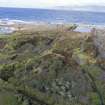
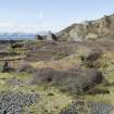
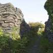
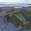
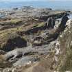
The pattern of garden enclosures on the 1872 map show the number required for the population by the early – mid 19th century. The walls are of dry-stone construction and are distinctive in the landscape. They are now generally abandoned and dense vegetation grows in them in contrast to the almost soil-less surroundings of slate waste.
The garden enclosures on Easdale vary in size and shape and to a certain extent, in distribution, over time. The three main ‘time slices’ used in the Easdale survey and which show the garden enclosures in detail are:
• 1st edition Ordnance Survey 25-inch map (Argyll, surveyed 1871, published 1872, sheets CXXI.6, 7, 10 and 11)
• 2nd edition Ordnance Survey 25-inch map (Argyll, surveyed 1898, published 1899, sheet CXXI.6, 7, 10 and 11)
• RAF aerial photograph of 1946 (see NCAP_SCOT_106G_SCOT_UK_0049_4267, 4th May 1946)
There are defined clusters of enclosures that appear on the 1st edition Ordnance Survey 25-inch map (Argyll, 1872, sheet CXXI.7 and 11) and the 2nd edition Ordnance Survey 25-inch map (Argyll, 1899, sheet CXXI.7 and 11). The concentrations are in the north of the island, along the south shore, a south west cluster, a central cluster and a small cluster to north of the east quarries (NM71NW 112 and 113). They are quite distinct from the back gardens attached to Easdale Village cottages.
This enclosure pattern remains a constant between 1872 and 1899, apart from loss of the western edge of the south west cluster around NM7349 1705 due to the opening up of quarries NM71NW 116, 117 and 118. There is evidence of erosion between 1872 and 1899 of the southernmost shore garden enclosures around NM7366 1698. Little changes until at least 1946 (see RAF aerial photo-graph (NCAP_SCOT_106G_SCOT_UK_0049_4267, 6 May 1946)). By 1899, around 128 enclosures are identifiable ranging in size from, for example, 865sq.m. at NM73710 17188 (now partially eroded) to 55 sq. m. at NM73590 17007. How the land was allocated to villagers and quarry workers by the landowner (Earls of Breadalbane until the 1930s) and how many individuals were supported by each plot is unknown. The population of Easdale Island in 1868 stood at about 450 (The Oban Times, December 26, 1868, quoting John White, Manager, Easdale Island quarries). Perhaps some of the larger plots may have been cultivated by several families?
Many of the enclosures lie on top of earlier slate waste such as at NM71NW 123 and NN71NW 124 (overlies waste from quarries NM71NW 114 and/or NM71NW 115 and NM71NW 121). Today (2019) the general pattern of garden enclosures is still identifiable and a few are still in use, including one used for raising pigs.
Visited by, and information from HES, Survey and Recording Section, (MMD) 9 September 2015/ 22 February 2019.

