
Easdale, Doune Quarry


Slate Quarry (19th Century)
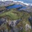
Site Name Easdale, Doune Quarry
Classification Slate Quarry (19th Century)
Alternative Name(s) Dun Quarry
Canmore ID 353999
Site Number NM71NW 121
NGR NM 73638 17136
Datum OSGB36 - NGR
Permalink http://canmore.org.uk/site/353999


- Council Argyll And Bute
- Parish Kilbrandon And Kilchattan
- Former Region Strathclyde
- Former District Argyll And Bute
- Former County Argyll
Desk Based Assessment (2019)
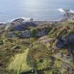
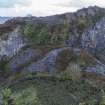
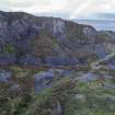
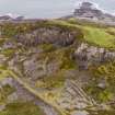
This quarry is probably 'Doune' or 'Dun' Quarry which sits to the south of NM71NW 115 (Hill Quarry). It does not appear on the 1st edition Ordnance Survey 25-inch map (Argyllshire, surveyed 1871, published 1872, sheet CXXI.7) nor on the 2nd edition Ordnance Survey 25-inch map (Argyllshire, surveyed 1898, published 1899, sheet CXXI.7), although spoil is shown in the area at the foot of the quarry edge on both maps (this quarry edge runs stretches west/east in the midde part of the island and has created a 'fin' like structure). This spoil is overlain by garden enclosures some of which do not appear on the 1st edition Ordnance Survey 25-inch map (Argyllshire, surveyed 1871, published 1872, sheet CXXI.7) suggesting some abandonment around NM7367 1716. The quarry appears on a map of 1850.
MacDonald (1978)
Information from HES, Survey and Recording Section, (MMD) 21 February 2019.

