Accessibility

Font Size

100% 150% 200%

Background Colour

Default Contrast
Close Reset

Easdale, Klondyke Quarry

Slate Quarry (Period Unassigned)

Site Name Easdale, Klondyke Quarry

Classification Slate Quarry (Period Unassigned)

Canmore ID 353998

Site Number NM71NW 120

NGR NM 73589 17108

Datum OSGB36 - NGR

Permalink http://canmore.org.uk/site/353998

Ordnance Survey licence number AC0000807262. All rights reserved.
Canmore Disclaimer. © Bluesky International Limited 2025. Public Sector Viewing Terms

Toggle Aerial | View on large map

Digital Images

Quarried area to south east of NM71NW 120, known as the 'Klondyke', view from south east
Quarried area to south east of NM71NW 120, known as the 'Klondyke', view from south eastQuarries NM71NW 117, NM71NW 118 (both flooded) and NM71NW120, west track and enclosure, view from high ground to eastSouth garden enclosures and track, view from west at NM73591 17005Quarry (NM71NW 118.00) and south garden enclosures around NM73560 17070, view from high ground to north eastOblique aerial view from south east showing Klondyke Quarry (right) with An Lub Chlear and An Toll mar Luaty quarries beyond, Fang Quarry (left) and walled garden enclosures which pre-date the quarries in this area.Oblique aerial view of Klondyke QuarryOblique aerial view showing detail of western part of Klondyke QuarryOblique aerial view from north east showing flooded quarries Fang, Klondyke, An Lub Chlear and An Toll Mar LuatyRemains of garden enclosures around  NM73627 16999 to south east of quarry NM71NW 117, view from south east. Tramway embankment also visible (NM73604 17002)South garden enclosures around NM73630 17002, view from southWest end of island, general view from high ground to eastTrack to east of quarry (NM71NW 120), view from south with quarry to the rightSouth garden enclosures to north east of quarry no.7 (NM71NW 118), and enclosures at NM75573 17057 and NM73559 17074, view from high ground to east. Part of NM71NW 120 can also be seen in right of image with some of its working areas identifiable at the lower level.Oblique aerial view from south of An Lub Chlear Quarry, Klondyke Quarry and the slate waste heap/ tipping NM71NW 149 Oblique aerial view of the west end of the islandQuarry NM71NW 117 (An Lub Chlear), general view from hill to eastQuarries NM71NW 117, 118 and 119.01 (An Lub Chlear, Fang and and Rudbha Nam Faoileann), and Klondye (NM71NW 120, foreground), view from hill to eastSouth garden enclosures and track, general view from south east at NM73639 16991 south east of NM71NW 120 (quarry)Track to south east of quarry NM71NW 117, view from south with quarry NM71NW 120 on the rightOblique aerial view of Klondyke QuarryOblique aerial view of Klondyke Quarry from the eastBoiler house, view from west. The Klondyke Quarry (NM71NW 120/ Canmore ID: 353998) sits behind it.Oblique aerial view from south west of south west spoil, walls and workings landscape, Fang Quarry and An Lub Chlear Quarry, village and HarbourEnclosure to south of quarry NM71NW 117 (An Lub Chlear), view from north westGeneral view of west end of island from high ground to north eastOblique aerial view showing the quarries Fang, An lub chlear, An Toll mar Luaty and Klondyke (dry). These all post date 1871 and pre-date 1898.Oblique aerial view of Klondyke Quarry. The garden enclosure at bottom left of image (at NM73559 17073) is the southern half of a larger enclosure the northern part of which  destroyed by the expansion of Klondyke Quarry (post-1872 and pre-1899).Oblique aerial view of the south western part of the island. The ridge running down the centre of the west of the island can be clearly seen , with quarries either side.Oblique aerial viewShoreline, track and south garden enclosures, general view from east at NM73639 16991Garden enclosures around NM7356 1706, to north east of quarry (NM71NW 118.00), view from south. Quarry NM71NW 120 in backgroundOblique aerial view Oblique aerial view showing Klondyke Quarry with An Lub Chlear and An Toll mar Luaty quarries beyond from eastOblique aerial view of Klondyke Quarry from east looking towards quarry faces and slate wasteOblique aerial view from south east looking towards Klondyke Quarry (extreme top right) and the flooded Fang Quarry (extreme left) with garden enclosures and the eroded slate waste shoreline.Oblique aerial view of Klondyke, Fang and An Lub Chlear quarriesQuarry NM71NW 118 (An Lub Chlear) and track, view from hill to east. Quarry NM71NW 120, 'Klondyke', right foregroundQuarries NM71NW 117 and 118 and 119 (An Lub Chlear, Fang and Rudbha Nam Faoileann/An Staca Dubh) and tramway track, spoil from the south west quarries and walls from view from hill to eastGarden enclosure enclosure to east of quarry NM71NW 118, view from south east with NM71NW 120, Klondyke Quarry in the backgroundSouth garden enclosures to north east of quarry no.7 (NM71NW 118), and enclosures at NM75573 17057 and NM73559 17074, view from high ground to east. Part of NM71NW 120 can also be seen in right of imageOblique aerial view showing Klondyke Quarry with An Lub Chlear and An Toll mar Luaty quarries beyond from eastOblique aerial view from south showing Klondyke Quarry with the extensive slate waste at its eastern end.Oblique aerial view of Klondyke quarry from eastHill, view from south westTrack to east of quarry (NM71NW 120), view from south with quarry on the rightOblique aerial view of An Lub Chlear and Klondyke Quarries as well as south spoil, walls and workingsOblique aerial view of Klondyke Quarry and south west spoil walls and workings and the eroded south foreshoreOblique aerial view of Klondyke Quarry

Administrative Areas

  • Council Argyll And Bute
  • Parish Kilbrandon And Kilchattan
  • Former Region Strathclyde
  • Former District Argyll And Bute
  • Former County Argyll

Activities

Desk Based Assessment (6 February 2019)

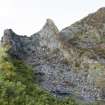
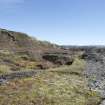
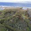
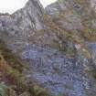
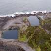
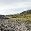
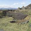
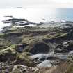
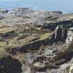
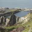
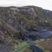
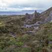
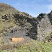
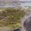
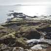
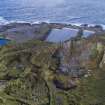
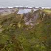
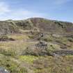
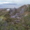
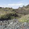
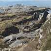
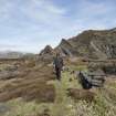
This quarry is depicted and named 'Quarry' on the 2nd edition of the Ordnance Survey 25-inch map (Argyllshire, revised 1898, published 1899, sheet CXXI.7). Locally known as the 'Klondyke' (Withall, 1994), this dates the quarry nickname to around 1896/7 (Klondyke gold rush in the Yukon, Canada, 1896-1899). It is mapped in 1898 with an approximate 0.19 hectares extent. Further quarrying in the 20th century has extended the quarry to the west increasing it to approx. 0.30 hectares. A number of slate working areas have been identified in this quarry, those in the west end presumably date from the 20th century quarrying. This quarry may be associated with the building NM71NW 136 (possible powder magazine or bothy). The northern extent of this quarry is defined by a dolerite dyke (see BGS Field-slips showing Easdale’s dolerite dykes in red sitting at right angles to the slate beds, Permit Number CP19/043 British Geological Survey © UKRI 2019).

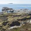
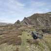
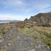
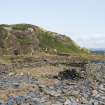
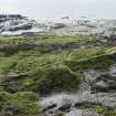
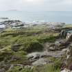
The tramway which served the quarry depicted and named on the Ordnance Survey 2nd edition map can be traced between the surviving garden enclosures to the south at NM73589 17045 and at NM73581 17030 where it runs through a now destroyed garden enclosure (depicted on the 1st edition of the Ordnance Survey 25-inch map (Argyllshire and Buteshire, surveyed 1871, published 1872, sheet CXXI.7)).

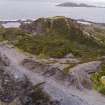
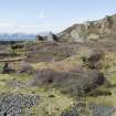
The 1st edition of the Ordnance Survey 25-inch map (Argyllshire and Buteshire, surveyed 1871, published 1872, sheet CXXI.7) does not show any quarrying in this area. A large group of garden enclosures are depicted, but the northern portion of these has been quarried away.

NRHE: MS8087/3

Information from HES, Survey and Recording Section, (MMD), 6 February 2019.

References

MyCanmore Image Contributions


Contribute an Image

MyCanmore Text Contributions