
Easdale, An Lub Chlear, Quarry


Slate Quarry (Period Unassigned)
Site Name Easdale, An Lub Chlear, Quarry
Classification Slate Quarry (Period Unassigned)
Alternative Name(s) The Clear Pool
Canmore ID 353995
Site Number NM71NW 117
NGR NM 73492 17128
Datum OSGB36 - NGR
Permalink http://canmore.org.uk/site/353995


- Council Argyll And Bute
- Parish Kilbrandon And Kilchattan
- Former Region Strathclyde
- Former District Argyll And Bute
- Former County Argyll
Field Visit (September 2015)
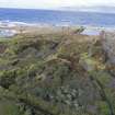
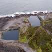
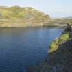
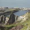
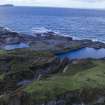
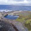
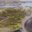
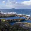
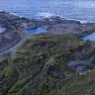
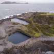
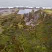
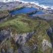
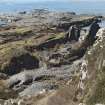
There was an expansion of quarrying activity in the north west area of the island of Easdale between 1871 and 1898. There is also evidence from a map of 1850 which shoes trial slate pits in this area. This now flooded quarry, along with quarres NM71NW 116 and NM71NW 118.0, is depicted and named on the 2nd edition Ordnance Survey 25-inch map (Argyllshire, surveyed 1898, published 1899, sheet CXXI.7).
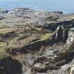
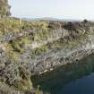
The oldest part of this quarry is at its southern end. The 1st edition Ordnance Survey 25-inch map (Argyllshire and Buteshire, surveyed 1871, published 1872, sheet CXXI.7) depicts an abandoned flooded quarry measuring some 636 square metres (0.16 acres). By 1899 the quarry has been reopened and expanded to the north east to some 4,515 square metres (1.16 acres). It has also been connected to the tramway system and was probably associated with the now ruinous Boiler House, Engine House and Forge (NM71NW 132,133,141 and 134).
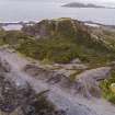
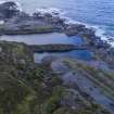
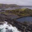
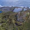
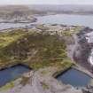
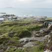
As with other coast quarries on Easdale, this quarry was below sea level at the maximum extent of its working life. Sea defence walls were built to keep the sea at bay and to give the pumps a chance of keeping the workings as dry as possible. The slate built sea defence wall at the north end of the quarry (around NM7346 1717) was partially visible by 1977 (see SC 489163). By the date of visit, however, the wall was no longer visible apart from some mortar traces on the outcrop. A further fragment of the return of this slate built wall (running south east) was visible immediately to the west of the quarry (see DP228101).
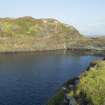
There is another wall made of concrete and measuring about 11.0m in length at NM 73472 17180 (see DP228099). This is not visible in a 1946 RAF aerial photograph (NCAP_SCOT_106G_SCOT_UK_0049_4267, 6 May 1946).
M MacDonald (1978)
Visited by HES, Survey and Recording Section, (MMD) 9 September 2015.

