Accessibility

Font Size

100% 150% 200%

Background Colour

Default Contrast
Close Reset

Easdale, An Toll Mar Luaty, Quarry

Slate Quarry (Period Unassigned)

Site Name Easdale, An Toll Mar Luaty, Quarry

Classification Slate Quarry (Period Unassigned)

Alternative Name(s) An Toll Mor Thicath

Canmore ID 353994

Site Number NM71NW 116

NGR NM 73505 17172

Datum OSGB36 - NGR

Permalink http://canmore.org.uk/site/353994

Ordnance Survey licence number AC0000807262. All rights reserved.
Canmore Disclaimer. © Bluesky International Limited 2025. Public Sector Viewing Terms

Toggle Aerial | View on large map

Digital Images

Oblique aerial view of An Toll Mar Luaty Quarry and later slate waste tipping as well as west coastal quarrying.
Oblique aerial view of An Toll Mar Luaty Quarry and later slate waste tipping as well as west coastal quarrying.Oblique aerial view of An Toll Mar Luaty and An Lub Chlear quarries from the west.Oblique aerial view showing edges of An Lub Chlear and An Toll Mar Luaty quarries and associated buildingsOblique aerial view from north east showing flooded quarries Fang, Klondyke, An Lub Chlear and An Toll Mar LuatyOblique aerial view of the west end of the islandSpoil to north of quarry NM71NW 116 showing unstable nature of the shale waste. This waste post-dates the quarry into which it is collapsingQuarry NM71NW 116 and boiler house (NM71NW 141), view from westOblique aerial view of west quarriesConcrete retaining wall north end of quarrySouth west corner of quarry looking towards Boiler House (NM71NW 141)Oblique aerial view of quarries An Toll Mar Luaty and An Lub ChlearOblique aerial view of west quarries from south with Windmill Quarry in backgroundOblique aerial view of An Toll Mar Luaty Quarry with remains of associated forge building and engine house with later slate waste tipping in the flooded quarryOblique aerial view of west coastal coastal and deep quarryingEasdale, Slate Quarries
General view from E showing flooded quarry NM71NW 116 from southwestOblique aerial view showing western quarries from northOblique aerial view showing the quarries Fang, An lub chlear, An Toll mar Luaty and Klondyke (dry). These all post date 1871 and pre-date 1898.Oblique aerial view from west with Fang and An Lub Chlear quarries nearest the camraOblique aerial view Oblique aerial view showing Klondyke Quarry with An Lub Chlear and An Toll mar Luaty quarries beyond from eastOblique aerial view of east end of Easdale showing Doune Quarry (foreground), Hill Quarry (right), An Toll Mar Luaty Quarry with later slate waste dumped into it, An Dub Chlear Quarry, and Fang Quarry (top left)Oblique aerial view of An Lub Chlear (left) and An Toll Mar Luaty Quarry (right) with later slate waste dumpingOblique aerial view of quarry An Toll Mar Luaty showing the slate waste dumped into it, possibly from the re-working phase of Hill/ Windmill Quarries in the early 20th century; west coastal quarrying evidence and sea erosion of slate wasteOblique aerial view of west quarriesOblique aerial view from south of An Toll Mar Luaty and An Lub Chlear Quarries as well as the engine house remainsQuarry NM71NW 116, view from westOblique aerial view showing Klondyke Quarry with An Lub Chlear and An Toll mar Luaty quarries beyond from eastOblique aerial view east edge of Hill Quarry and tramways which linked Windmill and Hill Quarries to the Harbour and linked to the western quarries An Toll Mar Luarty, An Lub Chlear and Fang.Oblique aerial view of An Toll Mar Luaty Quarry with remains of associated forge building and engine house with later slate waste tipping in the flooded quarryOblique aerial view from south showing the western quarries An Lub Chlear and An Toll Mar Luaty and the ruins of the boiler house (foreground), engine house and forge associated with these quarries.Oblique aerial view showing An Toll Mar Luaty (right) and tippingOblique aerial view of from west showing Hill, An Toll Mar Luaty and An Lub Chlear quarries

Administrative Areas

  • Council Argyll And Bute
  • Parish Kilbrandon And Kilchattan
  • Former Region Strathclyde
  • Former District Argyll And Bute
  • Former County Argyll

Activities

Note (September 2015)

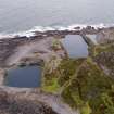
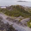
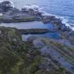
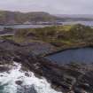
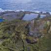
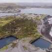
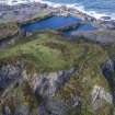
This now flooded quarry is one of eight main abandoned quarries on the island of Easdale. This quarry is not depicted on the 1st edition Ordnance Survey 25-inch map (Argyllshire and Buteshire, surveyed 1871, published 1872, sheet CXXI.7). It is depicted and named 'Old Quarry' and shown as flooded by 1899 (2nd edition Ordnance Survey 25-inch map (Argyllshire, surveyed 1898, published 1899, sheet CXXI.7)).

By 1869 it was noted that ‘railway inclines were constructed in all the quarries. These were at first worked by horses but for a number of years past steam power has been employed’ (Bremner, 1869). There may have been a lifting gantry or an incline plane to enable the slate to be brought up to tramway level for dispatch to the harbour (at NM7387 1709), but no visible evidence was noted on the date of visit. The 1899 map, however, shows a detail at NM73508 17150 of a turntable for wagons and two short lengths of tramway lines suggesting some kind of lifting gantry.

The waste from this quarry, and possibly NM71NW 117, could have been dumped along the waterline immediately to the north-of the quarries. The extensive waste slate shown on the 1871 map has eroded away exposing the quarried slate shore below. A significant amount of slate waste overlies the north west portion of the quarry and over the site of the tramway route depicted on the 1899 map, suggesting later quarrying activity to the north.

Visited by HES, Survey and Recording Section, (MMD) 8/9 September 2015.

Bremner (1869)

References

MyCanmore Image Contributions


Contribute an Image

MyCanmore Text Contributions