
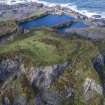
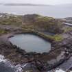
Easdale, Hill Quarry


Slate Quarry (Period Unassigned)
Site Name Easdale, Hill Quarry
Classification Slate Quarry (Period Unassigned)
Alternative Name(s) Creag Nam Duin; Quarry Of The Hill
Canmore ID 353993
Site Number NM71NW 115
NGR NM 73603 17261
Datum OSGB36 - NGR
Permalink http://canmore.org.uk/site/353993


- Council Argyll And Bute
- Parish Kilbrandon And Kilchattan
- Former Region Strathclyde
- Former District Argyll And Bute
- Former County Argyll
Field Visit
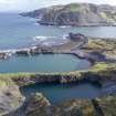
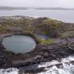
This now flooded quarry is known as Creag Nam Duin (or Quarry of the Hill). It is one of eight main quarries on Easdale Island, all of which are abandoned. This quarry is depicted and named 'Old Quarry' on the 1st edition Ordnance Survey 25-inch map (Argyllshire, surveyed 1871, published 1872, sheet CXXI.7) and so had been abandoned before 1871. The map evidence suggests that this quarry was re-worked after abandonment. There is a marked north extension of the quarry between 1872 and 1899 (see 1st edition Ordnance Survey 25-inch map (Argyllshire, surveyed 1871, published 1872, sheet CXXI.7)) and 2nd edition Ordnance Survey 25-inch map (Argyllshire, surveyed 1898, published 1899, sheet CXXI.7)). A photograph dating from c.1904 is further evidence of the reworking of this quarry (British Geological Survey, see http://geoscenic.bgs.ac.uk/asset-bank/action/viewAsset?id=1313&index=16&total=1000&view=viewSearchItem). The image clearly shows steam cranes lifting parcels of slate, tramway tracks and drill bits in the quarry. The drill bits would be for the insertion of explosives to loosen material. It is unclear what relationship (if any) this quarry had with the engine house NM71NW 131.0 (demolished by 1899 (from map evidence)).
By 1869 it was noted that ‘railway inclines were constructed in all the quarries. These were at first worked by horses but for a number of years past steam power has been employed’ (Bremner, 1869). As this quarry is flooded, any remnants of inclines are not visible from ground level.
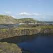
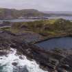
The waste from this quarry, and possibly from quarry NM71NW 114, could have been dumped along the waterline immediately to the north-west of the quarry. The tramway between the quarries extends north of the engine house (NM71NW 131.1) along a narrow causeway between this quarry and NM71NW 114 and depicts two branches running to the shoreline and terminating at NM71NW73514 17325 and NM73504 17314 respectively. A feature at NM73567 17312 which is 9.0m in length by 3.0m in width, and consisting of a hollow in slate waste which has been eroded at its northern end, may be part of the tramway (as on OS map, 1872). The extensive waste slate shown on the 1872 map has eroded away exposing the quarried slate shore below. There is also an area of slate waste to the west (around NM7372 1724) that may also be from the workings of NM71NW 115 and 114. Material may also have been dumped into the abandoned quarry, NM71NW 116. The dumped material is not depicted on the 2nd edition Ordnance Survey 25-inch map (Argyllshire, surveyed 1898, published 1899, sheet CXXI.7) but appears on a 1946 RAF aerial photograph (see NCAP_SCOT_106G_SCOT_UK_0049_4267, 6 May 1946) .
The solid slate causeway which carried the tramway between the quarries has had a breach in it that has been filled with slate masonry (at some unknown date) and acts to underpin the tramway route (see DP228083).
There are some remains of possible revetment in the slate waste below the tramway at the north end of the quarry. This may be part of the underpinning for the tramway which skirts the north end of the quarry and is post-1872 in date (see 2nd edition Ordnance Survey 25-inch map (Argyllshire, surveyed 1898, published 1899, sheet CXXI.7).
Bremner (1869); NRHE MS/8087/4
Visited by HES, Survey and Recording Section, (MMD) 8/9 September 2015.

