
Following the launch of trove.scot in February 2025 we are now planning the retiral of some of our webservices. Canmore will be switched off on 24th June 2025. Information about the closure can be found on the HES website: Retiral of HES web services | Historic Environment Scotland
Easdale, Windmill Quarry


Slate Quarry (Period Unassigned)
Site Name Easdale, Windmill Quarry
Classification Slate Quarry (Period Unassigned)
Alternative Name(s) Creag Na H-uamha; Quarry Of The Cave;
Canmore ID 353992
Site Number NM71NW 114
NGR NM 73647 17299
Datum OSGB36 - NGR
Permalink http://canmore.org.uk/site/353992


- Council Argyll And Bute
- Parish Kilbrandon And Kilchattan
- Former Region Strathclyde
- Former District Argyll And Bute
- Former County Argyll
Field Visit (9 September 2015)
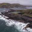
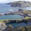
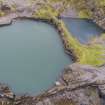
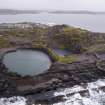
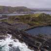
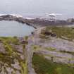
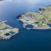
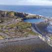
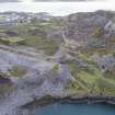
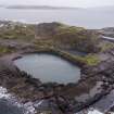
This now flooded quarry is one of eight main quarries on the island which are now abandoned. The ingress of sea water was a constant battle for the quarry workers. In 1807 a windmill was installed to pump water from this quarry. This pumping method was used for at least 20 years using a ‘seven-inch pipe from a depth of 50 feet’. In 1826 a steam engine was erected (possibly in NM71NW 131.01 - the sources are unclear on this point) to enable more efficient pumping.
This quarry, known as Windmill Quarry, was said to measure ‘250 feet in length and breadth and 120 feet in depth’ by the last quarter of the 19th century (Bremner, 1869). This quarry is depicted and named 'Quarry' on the 1st edition Ordnance Survey 25-inch map (Argyllshire, surveyed 1871, published 1871, sheet CXXI.7) and shows an incline for the slate wagons as well as four 'spurs' from the incline. The map seems to show three levels within the quarry perhaps indicating the extension of the workings to the north-west, over time. The quarry is associated with an 'Engine House' (NM71NW 131.01) depicted as roofed on the 1871 map and a 'Pump' (NM71NW 143). By 1869 it was noted that ‘railway inclines were constructed in all the quarries. These were at first worked by horses but for a number of years past steam power has been employed’ (Bremner, 1869). There may have been a lifting gantry of some kind to lift wagons/bogies to enable the slate to be brought up to tramway level for dispatch from the harbour, but no visible evidence was noted on the date of visit.
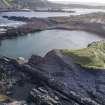
The waste form this quarry and possibly NM71NW 115, would have been dumped along the waterline immediately to the north-west of the quarry and elsewhere. The tramway linking the quarries extends north of the engine house (NM71NW 131.1) along a narrow causeway between this quarry and NM71NW 115 and depicts two branches running to the shoreline and terminating at NM71NW73514 17325 and NM73504 17314. A feature at NM73567 17312 which is 9.0m in length by 3.0m in width, and consisting of a hollow in slate waste which has been eroded at its northern end, may be part of the tramway (1871) north of the causeway. The extensive spoil shown on the 1871 map has eroded away exposing the quarried slate shore below.
By the 2nd edition Ordnance Survey 25-inch map (Argyllshire, surveyed 1898, published 1899, sheet CXXI.7), the associated buildings (NM71NW 131.01 and NM71NW 143) are no longer depicted and the quarry has been abandoned (depicted as 'Old Quarry'). The north end of the quarry is separated from the sea by a thin slate wall reinforced with masonry (now gone). This wall was probably breached in November 1881 during a storm, flooding the quarry (the same storm caused great damage to the quarry on Ellenabeich (NM71NW 15.0)).
There is a retaining quarry lip wall on the south edge of the quarry. This slate-built 'cavity' wall runs from NM7368917290 to NM73698 17314. The function of the gap in the wall (which varies between 0.2m and 0.25m in width) is unclear.
A 1946 aerial photograph (see 1946 RAF aerial photograph - NCAP_SCOT_106G_SCOT_UK_0049_4267, 6 May 1946) shows remnants of the sea defence wall as well as the quarry lip retaining cavity wall.
Bremner (1869)
Visited by HES, Survey and Recording Section, (MMD) 8/9 September 2015.

