
Easdale, East Engine Quarry


Slate Quarry (Period Unassigned)
Site Name Easdale, East Engine Quarry
Classification Slate Quarry (Period Unassigned)
Canmore ID 353991
Site Number NM71NW 113
NGR NM 74026 16980
Datum OSGB36 - NGR
Permalink http://canmore.org.uk/site/353991


- Council Argyll And Bute
- Parish Kilbrandon And Kilchattan
- Former Region Strathclyde
- Former District Argyll And Bute
- Former County Argyll
Desk Based Assessment (25 February 2019)
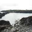
Along with the adjacent quarry, East Engine Quarry (NM71NW 112), Midd Engine Quarry (name from 1850 map in MacDonald, 1978) is possibly one of the earliest deep quarries on Easdale Island. The Easdale area (including Easdale Island) had been famous for their slate long before this with the easily won slate being taken from the coastline of the Island using oak wedges and water to split the rock - a version of the plug and feather method - and using sluices to keep the working areas dry between tides. The setting up of the Easdale Marble and Slate Company of Netherlorn in 1745 by John Campbell, 3rd Earl of Breadalbane saw the extraction of slate put onto a commercial footing. It is noted by Withall that by 1745 more than a million slates had been produced. Permanent workmen, better quarrying methods and pumps enabled the production of slate to increase. When Pennant visited the Easdale area (Eusdale), he noted that two and a half million slates had been produced using gunpowder and wheel barrows.
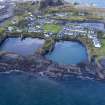
The quarry is depicted and named 'Old Quarry' on the 1st edition Ordnance Survey 25-inch map (Argyllshire, surveyed 1871, published 1872, sheet CXXI.11) and so had been abandoned by this time. The waste from this quarry and possibly NM71NW 112, could have been dumped into the sea and on the shoreline. The 1872 map depicts waste or spoil around the east shoreline. The erosion of the coastline, however, could have moved waste out to sea. The 18th century village is concentreated on the east end of the island suggesting a proximity to workings being desired by the owners and workers.
There is no evidence surviving of any tramways (horse tramways were first introduced in the 1830s and steam locomotives in later 19th century) which may suggest the quarry was either exhausted before the 1830s (horse and carts in use leaving little physical trace, apart from pathways) or that the evidence of the tramways has been obliterated by coastal erosion and remodelling. A map of 1850 shows a tramway running between this quarry and Midd Engine Quarry (NM71NW 113). It runs from c.NM7393 1707 (east side of Harbour) to c.NM7400 1684 (shoreline workings/dumping of slate waste).
D Bremner (1869); Withall (2013); T Pennant(1772); M MacDonald (1978).
Information from HES, Survey and Recording Section, (MMD) 11 February 2019.

