
Priestfield


Linear Feature(S) (Period Unknown), Mortuary Enclosure (Neolithic)(Possible), Rig And Furrow (Medieval) - (Post Medieval), Unenclosed Settlement (Prehistoric)
Site Name Priestfield
Classification Linear Feature(S) (Period Unknown), Mortuary Enclosure (Neolithic)(Possible), Rig And Furrow (Medieval) - (Post Medieval), Unenclosed Settlement (Prehistoric)
Canmore ID 35389
Site Number NO64NE 13
NGR NO 67331 48976
NGR Description NO centred 67331 48976
Datum OSGB36 - NGR
Permalink http://canmore.org.uk/site/35389


- Council Angus
- Parish Inverkeilor
- Former Region Tayside
- Former District Angus
- Former County Angus
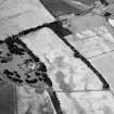
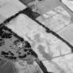
Oblique aerial photographs (RCAHMSAP 1995) have revealed five ring-ditches, to the SE and NE of a palisaded enclosure (NO64NE 12). Immediately to the N of the enclosure, a rectilinear structure is visible, measuring about 25m E-W by 10m transversely.
Information from RCAHMS (KJ) 17 May 1999.
Field Visit (March 1978)
Priestfield NO 673 488 NO64NE
Air photography has revealed faint traces of a number of ring-ditches measuring up to about 10m in diameter, in the vicinity of the palisaded homestead (NO64NE 12) to the NW of Anniston.
RCAHMS 1978, visited March 1978
Aerial Photographic Transcription (2 February 2001 - 8 April 2001)
An aerial transcription was produced from oblique aerial photographs. Information from Historic Environment Scotland (BM) 31 March 2017.

