
Priestfield


Barrow(S) (Prehistoric)(Possible), Palisaded Settlement (Prehistoric), Rig And Furrow (Medieval) - (Post Medieval), Roundhouse (Prehistoric)
Site Name Priestfield
Classification Barrow(S) (Prehistoric)(Possible), Palisaded Settlement (Prehistoric), Rig And Furrow (Medieval) - (Post Medieval), Roundhouse (Prehistoric)
Canmore ID 35388
Site Number NO64NE 12
NGR NO 67312 48868
NGR Description NO centred 67312 48868
Datum OSGB36 - NGR
Permalink http://canmore.org.uk/site/35388


- Council Angus
- Parish Inverkeilor
- Former Region Tayside
- Former District Angus
- Former County Angus
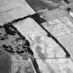
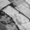
These cropmarks are now classified as a palisaded enclosure. In the surrounding area ring-ditches and a rectilinear structure are visible (see NO64NE 13).
Information from RCAHMS (KJ) 17 May 1999.
Field Visit (March 1978)
Priestfield NO 673 488 NO64NE
The crop-mark of a palisaded homestead has been identified in the field immediately NW of Anniston. The area enclosed by the palisade is oval and measures about 35m in maximum diameter, and contains a circular hut about 15m in diameter. Outside the palisade there is another circular mark, which may represent a hut of similar size, and there are also faint traces of what may be a field-system.
RCAHMS 1978, visited March 1978
Aerial Photographic Transcription (2 February 2001 - 8 April 2001)
An aerial transcription was produced from oblique aerial photographs. Information from Historic Environment Scotland (BM) 31 March 2017.

