
Following the launch of trove.scot in February 2025 we are now planning the retiral of some of our webservices. Canmore will be switched off on 24th June 2025. Information about the closure can be found on the HES website: Retiral of HES web services | Historic Environment Scotland
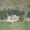
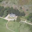
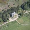
Birse Castle


Tower House (Medieval), Cheese Press (Period Unassigned)
Site Name Birse Castle
Classification Tower House (Medieval), Cheese Press (Period Unassigned)
Alternative Name(s) Forest Of Birse Castle
Canmore ID 35321
Site Number NO59SW 1
NGR NO 52019 90560
Datum OSGB36 - NGR
Permalink http://canmore.org.uk/site/35321


- Council Aberdeenshire
- Parish Birse
- Former Region Grampian
- Former District Kincardine And Deeside
- Former County Aberdeenshire
NO59SW 1.00 52019 90560
NO59SW 1.01 51952 90525 Kennels
(NO 5201 9054) Birse Cstle (NAT) on site of (NAT) Castle (NR)
OS 6" map, (1959)
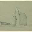
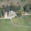
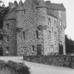
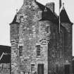
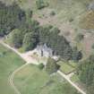
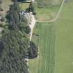
Originally a square, rubble-built tower house with turrets and at the SE angle a circular tower corbelled to square, Birse Castle was built about 1600 for the Gordons of Cluny who owned the surrounding Forest of Birse. By 1887 it was a fragmentary ruin, but it was restored in 1905 to its original form except that the circular tower was altered in shape. In 1930 a three-storey E wing was added. Tradition says that the Bishops of Aberdeen, who had a grant of the forest as early as 1242, also had a hunting seat in the forest. In Smith's time Birse Castle was believed to be that seat.
D MacGibbon and T Ross 1887-92; New Statistical Account (NSA) 1845; A Jervise 1875-9; HBD No. 15.
From sketches available at the Castle it appears that the original castle has been heavily restored. The building is occupied and is the property of Viscount Cowdry, Dunecht House, Dunecht, Aberdeen.
Visited by OS (AA) 15 August 1972.
(NO 5201 9054) Birse Castle (NR) (restored)
OS 1:10,000 map, (1975)
The Forest of Birse consisted of twenty-four towns, or farms, eighteen of which between 1574 and 1636 came into the hands of Gordon of Cluny. About 1610 this family, by building a castle, encroached upon the forest. The inhabitants of the other six farms claimed rights over the whole forest about 1640 they vindicated their rights by burning the castle and turning the tilled land into commonage and so held it for eighty years.
M L Anderson 1967.
Listed.
Scottish Castle Survey 1988; N Bogdan and I B D Bryce 1991.
NO59SW 1.00 52019 90560
EXTERNAL REFERENCE
Scottish Magazine May 1931 (photograph)

