
Ardhallow Battery


Wall (20th Century)
Site Name Ardhallow Battery
Classification Wall (20th Century)
Canmore ID 352939
Site Number NS17SE 6.31
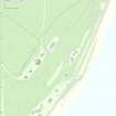
NGR NS 16271 74143
NGR Description NS 16251 74120 to NS 16287 74162
Datum OSGB36 - NGR
Permalink http://canmore.org.uk/site/352939


- Council Argyll And Bute
- Parish Dunoon And Kilmun
- Former Region Strathclyde
- Former District Argyll And Bute
- Former County Argyll
Field Visit (15 June 2016)
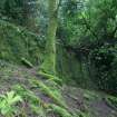
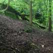
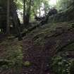
A concrete revetment wall measuring at least 60m in length from NE to SW by up to 2m in height has been built about 40m in front of the gun emplacements (NS17SE 6.9 and 21). The wall may not have been part of the original design of the battery. Documentation contained within the Fort Record Book (National Archives: WO 192/105) records how the private residences below the battery were damaged when the guns were first tested in November 1905 and how they were subsequently purchased by the War Office in 1907. The construction of the wall may have been a response to the threat of the slope in front of and below the guns becoming unstable.
Visited by HES Survey and Recording (AKK) 15 June 2016.

