
Eigg, Corragan Mor


Hut(S), Pen(S)
Site Name Eigg, Corragan Mor
Canmore ID 352934
Site Number NM48NE 197
NGR NM 4945 8869
Datum OSGB36 - NGR
Permalink http://canmore.org.uk/site/352934


- Council Highland
- Parish Small Isles
- Former Region Highland
- Former District Lochaber
- Former County Inverness-shire
Field Visit (23 April 2002)
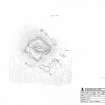
There is a group of six huts and three pens among boulders below the fort at Corragan Mor (NM48NE 56). The largest hut (1074) is situated 15m from the fort wall on the SE side. It is sub-rectangular on plan and measures 3.5m from NW to SE by 1.5m transversely within a drystone wall 0.6m in thickness and 0.4m in height. Two (249, 1078) of the other five are situated to the 17m NW and 19m E of the fort respectively, while a group of three (1075, 1079, 1080) stand 20m to the its SW. There are also three pens (1077, 1080-1), the largest of which measures 2m in internal diameter. Fragments of dyke among the boulders were presumably built to aid the management of stock.
EIGG01 249, 1074-81
Visited by RCAHMS (AGCH) 23 April 2002
Measured Survey (12 October 2002)
RCAHMS surveyed the fort at Corragan Mor on 12 October 2002 with plane-table and self-reducing alidade at a scale of 1:500. The plan was later used as the basis of an illustration that was published in 2016 (Hunter, fig. 3.18).

