
Ardhallow Battery


Boundary Stone (First World War)
Site Name Ardhallow Battery
Classification Boundary Stone (First World War)
Canmore ID 352873
Site Number NS17SE 6.13
NGR NS 16139 73956
Datum OSGB36 - NGR
Permalink http://canmore.org.uk/site/352873


- Council Argyll And Bute
- Parish Dunoon And Kilmun
- Former Region Strathclyde
- Former District Argyll And Bute
- Former County Argyll
Field Visit (15 June 2016)
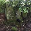
This boundary stone, one of a series that demarcated the land purchased by the War Department in 1899 (National Archives: WO192/195) for the Ardhallow Gun Battery (NS17SE 6), has been set into a rubble wall on the NNE side of the former driveway to Gairhill. The stone measures 0.31m in width and at least 0.64m in height, the lower 0.12m of which is more roughly tooled, perhaps suggesting that the stone was originally intended to be set into the ground. On the W face there is an inscription ‘W’ and ‘D’ flanking an upward pointing arrow, below which is ‘No.7’.
Visited by HES Survey and Recording (GFG) 15 June 2016.

