
Ardhallow Battery


Boundary Stone (First World War)
Site Name Ardhallow Battery
Classification Boundary Stone (First World War)
Canmore ID 352872
Site Number NS17SE 6.12
NGR NS 16246 73901
Datum OSGB36 - NGR
Permalink http://canmore.org.uk/site/352872

- Council Argyll And Bute
- Parish Dunoon And Kilmun
- Former Region Strathclyde
- Former District Argyll And Bute
- Former County Argyll
Field Visit (15 June 2016)
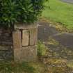
This boundary stone, one of a series that demarcated the land purchased by the War Department in 1899 (National Archives: WO192/195) for the Ardhallow Gun Battery (NS17SE 6), has been incorporated into the foot of a sandstone pillar standing about 1.2m in height at the SE corner of the garden of No.1 Ardhallow Cottages. The stone measures 0.45m square by 0.23m in height and on its SW face there is an inscription ‘W’ and ‘D’ flanking an upward pointing arrow, below which is ‘No.1’. Below this again, is the inscription ‘F.W. to 5’ and an arrow pointing W.
This stone originally stood some 123m to the NNE (see NS17SE 6.39),where it was placed when the land on which the gun battery was built was purchased in 1899. However, when an additional area of land was added to the SW end in 1907 the boundary was redrawn and stone 1 moved to its current position. The legend 'F.W. to 5' was added to this stone to reflect that in the redrawn boundary stones 2, 3 and 4 (NS17SE 6.46, 6.45 and 6.44) were redundant and stone 5 (NS17SE 6.35) was the next one in the series, linked to stone 1 by a length of field wall.
Visited by HES Survey and Recording (GFG) 15 June 2016.

