
Ardhallow Battery


Gun Emplacement(S) (First World War)
Site Name Ardhallow Battery
Classification Gun Emplacement(S) (First World War)
Canmore ID 352869
Site Number NS17SE 6.09
NGR NS 16227 74155
Datum OSGB36 - NGR
Permalink http://canmore.org.uk/site/352869


- Council Argyll And Bute
- Parish Dunoon And Kilmun
- Former Region Strathclyde
- Former District Argyll And Bute
- Former County Argyll
Field Visit (16 June 2016)
There were two 6-inch guns at Ardhallow battery as shown on the plan of the battery (National Archive: WO 78/5186) which stood in open emplacements. During the Second World War a gun-house was constructed over each emplacement and these are visible on aerial photographs (614.C) dated 3.2.41 contained within the Fort Record Book (National Archives: WO 192/105).
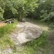
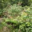
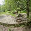
Of the N gun (NS 16237 74169), the presence of very dense vegetation except on the glacis prevented any detailed recording on the date of visit. The glacis or apron of the S gun (NS 16214 74144) remains extant, measuring about 4m in breadth from top to bottom though its SW end appears to have been damaged. A short length of wall extends NW from the N corner of the glacis, its SW side containing a recess for a light fitting. On top of the wall are traces of later brick work possibly for the Second World War gun house constructed over the emplacement.
The rest of the emplacement, including its sunken magazine and crew shelter, are buried and no longer visible. However, according to a plan of the battery (National Archives: WO 78/5186), the layout of the buildings is almost identical to those at the Portkil Battery (see NS28SE 39.01), though the crew shelter is slightly smaller and has a SAA (small arms ammunition) store on its N side.
Visited by HES Survey and Recording (AKK) 16 June 2016.

