
Cloch Point Battery


Military Building (First World War)
Site Name Cloch Point Battery
Classification Military Building (First World War)
Canmore ID 352825
Site Number NS27NW 21.34
NGR NS 20408 75602
Datum OSGB36 - NGR
Permalink http://canmore.org.uk/site/352825


- Council Inverclyde
- Parish Inverkip
- Former Region Strathclyde
- Former District Inverclyde
- Former County Renfrewshire
Field Visit (3 March 2016)
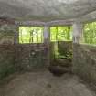
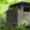
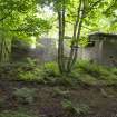
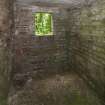
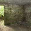
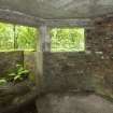
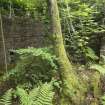
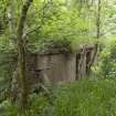
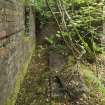
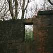
What may be an Extended Defence Officers (XDO) building and a Mine Watching Service Post lies to the W of and downslope from the Fire Command Post (NS27NW 21.03). The brick-and-concrete building is orientated NE and SW and contains three rooms. The central and SW room share a flat concrete roof and both have an entrance on the SE. The SW room contains a triangular stove base in its S corner and a three-sided observation bay on the NW. Two facets of this bay contain windows whilst the central has a doorway leading out onto a small projection little more than 1m square around which there is a waist-high brick parapet. The top of this parapet bears evidence that it probably once supported a timber superstructure that would have contained windows and incorporated a timber roof. The central room has a single window on the NW and there is a small hatch in the wall separating it from the SW room. The NE room, which may be a later addition to the building, has two windows in its NW side and at least one, plus an entrance, on the SE, though part of the wall here has collapsed. The room is currently open to the elements but it once had a sloping corrugated roof. In the interior is a concrete plinth set slightly NE of the centre of the room, which may have provided a solid base on which to house a galvanometer. A galvanometer measures electric current and was an integral part of the defensive system on the Clyde which used a series of indicator loops laid across the bed of the estuary designed to register magnetic changes which occur when metal ships or submarines pass overhead. These changes would then be measured by the galvanometer and, based on the interpretation of these changes, decisions would then be made as to the appropriate course of action. If enemy vessels were identified or suspected then mines within the controlled minefield would have been detonated remotely. The position of this observation post would also have afforded an excellent view of the Clyde and provided opportunities to observe and plot mines dropped by enemy planes into the shipping channel - similar to the Mine Watching Service post at the South Sutor, Cromarty (see NH86NW 11.23). Further, as well as being in a good position to control navy activity in this area, this post would also have been well placed to oversee the operation of the anti-submarine boom between Cloch Lighthouse and Dunoon, just to the N (NS27NW 137).
Visited by HES Survey & Recording (AM, AKK) 3 March 2016.
Measured Survey (1 March 2016)
HES surveyed the Extended Defence Officers (XDO) building, Cloch Point Battery on 1 March 2016 at a scale of 1:00. The resultant plan and north-west elevation were redrawn in vector graphics software.

