
Eigg, Laig


Building(S) (19th Century), Footbridge (20th Century), Township (Post Medieval), Track (Period Unassigned)
Site Name Eigg, Laig
Classification Building(S) (19th Century), Footbridge (20th Century), Township (Post Medieval), Track (Period Unassigned)
Canmore ID 352656
Site Number NM48NE 134
NGR NM 46658 87659
Datum OSGB36 - NGR
Permalink http://canmore.org.uk/site/352656


- Council Highland
- Parish Small Isles
- Former Region Highland
- Former District Lochaber
- Former County Inverness-shire
Field Visit (6 July 2001)
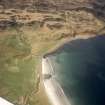
The remains of the township of Laig are represented by at least six sub-rectangular buildings, fragments of trackway and the remains of a footbridge to the S and SW of the 18th century Laig farmhouse (NM48NE 33). Three of the buildings (607, 608, 612) are relatively large and have probably been byre-houses. The largest (608) measures 8.9m from N to S by 3.6m over faced rubble walls 0.9m in thickness and 1m in height. Each of the external corners is rounded while the internal corners are squared, and there is an entrance in the E wall.
The settlement and farmland is shown in some detail on Bald’s map of 1806, and an outline of its history is provided in recent summaries of the island’s story (Wade Martins 2004 edn, Dressler 1998). Three of these buildings are shown on the1st edition of the OS 6-inch map (Inverness-shire (Skye) Sheet LXXI, 1879); two are roofed (608, 611) and one is unroofed (612). Two roofed buildings and the footbridge are shown on the 2nd edition published in 1904.
(EIGG01 607-613)
Visited by RCAHMS (AGCH) 6 July 2001

