
Toward Battery


Military Building (Second World War)
Site Name Toward Battery
Classification Military Building (Second World War)
Canmore ID 352450
Site Number NS16NW 16.71
NGR NS 12325 68116
Datum OSGB36 - NGR
Permalink http://canmore.org.uk/site/352450


- Council Argyll And Bute
- Parish Dunoon And Kilmun
- Former Region Strathclyde
- Former District Argyll And Bute
- Former County Argyll
Field Visit (20 October 2016)
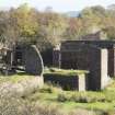
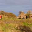
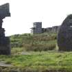
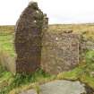
The remains of this building are situated within the eastern compound that contained accommodation - immediately north of the main access road that runs along the inside of the southern edge of the gun battery. It originally comprised two nissen huts linked by a short enclosed passage, but except for a section of the eastern end wall of the western hut, which preserves the shape of the original curving roof, it has been reduced to little more than two concrete rafts. The western raft stands 1m high on the south and measures 10.9m from E to W by 5m transversely. There is a short flight of concrete steps at the centre of the W end leading down to the north. Its brick porch lies entirely collapsed. A concrete stove-base measuring 0.55m square overall is situated on the central axis of the building 2.7m from the entrance. This hut was linked to the eastern hut by a short passage with a flat concrete roof that has collapsed leaving only a portion of its S wall which contains the remains of a window. The eastern raft measures 10.7m from N to S by 5m transversely and it, too, because it is situated on a natural slope, stands over 1m high at its S end. Here, there is set of concrete steps leading down to the east, with the top landing having a brick-built porch which is now devoid of its original concrete cap. A second entrance and set of steps is visible on the E side.
The precise use of the two NAAFI buildings is not recorded in the documentation contained within the Fort Record Book (National Archives: WO 192/113) but the disposition of the two nissen-type huts in relation to one another may be compared with a similar arrangement at the Workington coastal battery. Here, the former manageress of the NAAFI at 406th Coastal Battery recalled that she was billeted in a ‘little room with three beds, attached to the NAAFI’. (http://www.users.globalnet.co.uk/~rwbarnes/ defence/anecdote.htm#leemans) -- accessed 10 November 2016
Visited by HES Survey and Recording (JRS, AK, AMcC) 20 October 2016.

