
Toward Battery


Garage (Second World War), Water Tank (Second World War)
Site Name Toward Battery
Classification Garage (Second World War), Water Tank (Second World War)
Canmore ID 352432
Site Number NS16NW 16.63
NGR NS 12378 68158
Datum OSGB36 - NGR
Permalink http://canmore.org.uk/site/352432


- Council Argyll And Bute
- Parish Dunoon And Kilmun
- Former Region Strathclyde
- Former District Argyll And Bute
- Former County Argyll
Field Visit (20 October 2016)
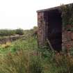
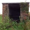
This garage, which once house fire fighting apparatus, stands close to the centre of the cluster of buildings in the eastern half of the battery. Rectangular on plan, it is a brick-built structure set on a substantial concrete raft and with a gently sloping concrete roof (0.15m thick). It measures 4.4m from NE to SW by 3.5m transversely over walls 0.36m thick and up to 2.6m in internal height on the SE and 2.46m on the NW. There is a broad gap (1.75m wide) in the NE side which originally held a timber doorway 1.64m wide and 2m high. The gap above the missing wooden lintel and the underside of the concrete roof probably had a timber filling. However, this doorway represents a secondary filling of a gap 2.3m wide which is represented by straight vertical joints in the brickwork that reach as high as the concrete roof. There is a concrete ramp leading down and out from the entrance.
The static tank, which lies immediately to the south-east, held water that would have been pumped by a portable engine to put out fires. Rectangular on plan, it measures 11.1m from NE to SW by 6.5m transversely over a brick wall 0.24m in thickness topped by a square-sectioned concrete cope. The tank is set into the slope on the NW and SW to a depth of at least 1.35m and supported on the NE and SE by an external bank. Contemporary vertical aerial photographs give the impression that the tank was split into two halves from by a subdivision running from NW to SE. This is not substantiated by what is visible today.
Visited by HES Survey and Recording (JRS, AK, AMcC) 20 October 2016.

