
Toward Battery


Hut (Second World War)
Site Name Toward Battery
Classification Hut (Second World War)
Canmore ID 352421
Site Number NS16NW 16.52
NGR NS 12452 68130
Datum OSGB36 - NGR
Permalink http://canmore.org.uk/site/352421


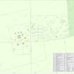
- Council Argyll And Bute
- Parish Dunoon And Kilmun
- Former Region Strathclyde
- Former District Argyll And Bute
- Former County Argyll
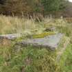
Field Visit (20 October 2016)
All that now remains of this hut, which was largely of timber construction and probably measured no more than about 8m in length, is the concrete floor of a small toilet block that was attached to the centre of its front (south) side. This floor, which is supported on a low brick plinth and is cracked and partly displaced, measures 2.55m from N to S by 2.3m transversely and it originally supported brick walls, including an internal partition of a toilet cubicle in its SE corner. Nothing is now visible of the timber element of the building, which is visible on a vertical aerial photograph taken in February 1941 (RAF 614.C). It is also depicted on site-plans contained within the Fort Record Book (National Archives: WO 192/113), and variously labelled ‘ATS Quarters’, or simply ‘ATS’.
Visited by HES Survey and Recording (JRS, AK, AMcC) 20 October 2016.

