
Toward Battery


Mess (Second World War)
Site Name Toward Battery
Classification Mess (Second World War)
Canmore ID 352411
Site Number NS16NW 16.50
NGR NS 12443 68144
Datum OSGB36 - NGR
Permalink http://canmore.org.uk/site/352411


- Council Argyll And Bute
- Parish Dunoon And Kilmun
- Former Region Strathclyde
- Former District Argyll And Bute
- Former County Argyll
Field Visit (20 October 2016)
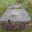
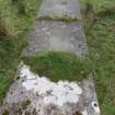
This building was constructed sometime between 21 October 1941, when it was not recorded on a vertical aerial photograph (7977.C309), and 23 February 1942, the date of a site-plan contained within the Fort Record Book (National Archives: WO 192/113), which labels the building ‘ATS Mess’. This building replaced two earlier buildings used for ATS accommodation (NS16NW 16.48 & 49). All that is now visible of the mess are two concrete rafts, each supported on low brick plinths on the south to take account of the natural slope. The western raft measures about 3.3m in length from N to S by 1.52m in breadth at its N end, but it reduces to 1.2m towards the S south end. The other raft lies 8.7m to the east. It measures 3.2m from N to S by 1.05m transversely and at its north end there are the remains of a toilet downpipe. A further site-plan, dating from April 1944, indicates that the building was then in use as a ‘billet’.
Visited by HES Survey and Recording (JRS, AK, AMcC) 20 October 2016.

