
Blackhills


Cairnfield (Prehistoric), Field System (Prehistoric), Hut Circle (Prehistoric)
Site Name Blackhills
Classification Cairnfield (Prehistoric), Field System (Prehistoric), Hut Circle (Prehistoric)
Canmore ID 35239
Site Number NO58SW 4
NGR NO 5414 8062
Datum OSGB36 - NGR
Permalink http://canmore.org.uk/site/35239


- Council Angus
- Parish Lochlee
- Former Region Tayside
- Former District Angus
- Former County Angus
NO58SW 4.00 5414 8062 and 541 809.
NO58SW 4.01 NO 54 80 Burial
(Area: NO 541 809) Cairns (NR)
OS 6" map, Forfarshire and Angus, 2nd ed., (1903)
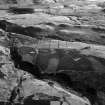
A field system of clearance heaps with stony field banks in the S part. No hut circles are visible, but the type and distribution of the clearance heaps are typical of those which accompany huts. The heaps vary in shape and size, some being circular, 2.0m to 4.0m in diameter, and some elongated, about 4.0m by 2.0m generally. All are about 0.2m, to 0.5m, in height.
Visited by OS (JLD) 29 July 1958.
An ill-defined, circular, stone-walled hut at NO 5414 8062, and a contemporary field system centred at NO 540 810. The hut, at the base of a slight natural scarp, is visible as a platform surrounded by an ill-defined wall measuring about 8.5m in diameter between its centres. The entrance is not evident.
The field system comprises stone clearance heaps, lynchets, and traces of a few ruinous walls, marking cultivation plots varying between about 45.0m by 25.0m and 25.0m by 20.0m. The SW part has recently been reclaimed and is used for rough grazing.
Hut surveyed at 1:10,000.
Visited by OS (AA) 11 November 1971.
(NO 5414 8062) Hut Circle (NR)
(Name: NO 541 809) Field System (NR)
OS 1:10,000 map, (1975)
At NO 5380 8143, NO 5381 8118 and NO 5407 8143 are obvious cairns, and there are other remains that look like hut circles.
Information from OS revisor 1975.

