
Toward Battery


Signalling Structure (Second World War)
Site Name Toward Battery
Classification Signalling Structure (Second World War)
Canmore ID 352383
Site Number NS16NW 16.25
NGR NS 12244 68112
Datum OSGB36 - NGR
Permalink http://canmore.org.uk/site/352383


- Council Argyll And Bute
- Parish Dunoon And Kilmun
- Former Region Strathclyde
- Former District Argyll And Bute
- Former County Argyll
Field Visit (20 October 2016)
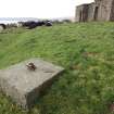
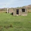
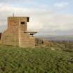
A signalling mast once stood immediately WSW of the B.O.P. Command Post (NS16NW 16.01). It stood on a concrete base at the centre of a levelled stance measuring about 9m square and 0.5m high on the south, and was tethered by four stays anchored to concrete blocks 0.7m square set into the ground at the corners of the stance. On the date of visit only the blocks at the SE and SW corners of the stance were visible.
Visited by HES Survey and Recording (JRS, AK, AMcC) 20 October 2016.

