
Toward Battery


Coal Store (Second World War)
Site Name Toward Battery
Classification Coal Store (Second World War)
Canmore ID 352359
Site Number NS16NW 16.11
NGR NS 12213 68121
Datum OSGB36 - NGR
Permalink http://canmore.org.uk/site/352359

- Council Argyll And Bute
- Parish Dunoon And Kilmun
- Former Region Strathclyde
- Former District Argyll And Bute
- Former County Argyll
Field Visit (20 December 2016)
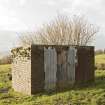
This structure stand on the west side of the cluster of building within the western part of the battery and is annotated ‘Coal Store’ on a contemporary plan in the Fort Record Book (National Archives: WO 192/113). It is a roofless brick-built structure measuring 3.47m square over a wall (0.24m thick) standing over 2.3m in height. This wall is topped by a 0.06m thick layer of cement into which has been set the steel supports for a low barbed-wire fence. In the ENE side there is a 2.26m wide gap with a concrete lintel which is currently closed-off with corrugated sheet metal. The interior of the structure, which could not be accessed on the date of visit, is overgrown with elder.
Visited by HES Survey and Recording (JRS, AK, AMcC) 20 October 2016.

