
Toward Battery


Storehouse (Second World War)
Site Name Toward Battery
Classification Storehouse (Second World War)
Canmore ID 352356
Site Number NS16NW 16.08
NGR NS 12245 68127
Datum OSGB36 - NGR
Permalink http://canmore.org.uk/site/352356


- Council Argyll And Bute
- Parish Dunoon And Kilmun
- Former Region Strathclyde
- Former District Argyll And Bute
- Former County Argyll
Field Visit (20 October 2016)
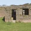
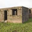
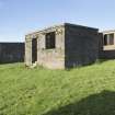
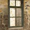
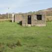
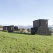
This store (annotated ‘Gun Store’ on a plan contained within the Fort Record Book (National Archives: WO 192/113) stands 11.5m NW of the Battery Observation Post (NS16NW 16.01) and is a brick-built structure set on a substantial concrete raft and with a flat (0.15m thick) concrete roof. Rectangular on plan, it measures 5.45m from ENE to WSW by 3.91m transversely over walls 0.5m thick, with an entrance (0.85m wide) in the SSE side set just 0.83m from the internal SW corner. There is a window opening (1.2m wide) with an external sloping sill in the SSE side, set 0.48m from the internal SE corner. Two windows openings, both 0.59m wide and complete with frames and both vertical and horizontal glazing bars but no glass, are set into the NNW wall, 1.1m and 1.12m respectively from the NE and NW corners. The roof slopes gently from SSE, where the internal height is 2.55m, to the NNW (2.49m). Situated slightly S of the midpoint of the ceiling along the WSW side there is a circular aperture for a stove-pipe and in the centre of the ceiling there are the remains of an electric light fitting.
Visited by HES Survey and Recording (JRS, AK, AMcC) 20 October 2016.

