
Sanday, Styes Of Brough


Burial(S) (Viking)(Possible), Cairn(S) (Period Unassigned)
Site Name Sanday, Styes Of Brough
Classification Burial(S) (Viking)(Possible), Cairn(S) (Period Unassigned)
Alternative Name(s) Sties Of Brough
Canmore ID 3523
Site Number HY64SE 30
NGR HY 6541 4213
NGR Description HY 6541 4213 and HY 6546 4216
Datum OSGB36 - NGR
Permalink http://canmore.org.uk/site/3523


- Council Orkney Islands
- Parish Cross And Burness
- Former Region Orkney Islands Area
- Former District Orkney
- Former County Orkney
HY64SE 30 6541 4213 and 6546 4216
See also HY63NE 10 and HY64SE 18.
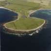
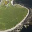
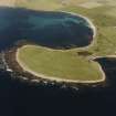
At HY 6541 4213 and HY 6546 4216 are the remains of two cairns ('A' and 'B' respectively)
'A' a robbed cairn survives as a rim of cairn material measuring c14.0m in diameter overall, by 0.4m in height. A slab on edge, facing NE-SW, protrudes through the turf in the SE arc.
'B', prominently situated on a rise, survives as a disturbed turf-covered mound c10.0m in diameter and 0.3m high.
Possibly the source of the Viking sword.
(See HY64SE18 and HY63NE 10).
Surveyed at 1/2500.
Visited by OS (AA) 13 July 1970.
Field Visit (1999)
Four mounds, of which three lie within the area under investigation by this survey, were previously identified as probable Viking burials due to chance finds of Viking-period artifacts (HY64SE26) said to have been made in the area. Recent assessment has indicated that the mounds are of prehistoric date, although a disturbed boat-shaped setting was found which may be part of a Viking burial setting. The southernmost mound (HY64SE18) is 30m in diameter. It is prominently located on a natural rise, has a conical shape and lies within 10m of the coast. The surface is pitted and stony. A low grass-covered bank runs off for some 10m from the east side of the mound. A second mound (HY64SW30,'B'), 10m in diameter and lies c.45m to the northeast. The surface is uneven and stony with what may be part of a structural feature. The third mound (HY64SW18, 'A') lies to the north, is oval in shape and measures 13m by 11m. It stands to 1m high and lies 18m from the sea. Ref.: Orkney Name Book, no.2, 73; Grieg, S (1940) 'Viking Antiquities in Great Britain and Ireland: part II' 171-2; RCAHMS (1946), #188; RCAHMS (1980), #132; Hunter, JR & Dockrill, SJ (1982) 'Some Norse Sites on Sanday, PSAS, 112, 570-76; Owen, O & Dalland, M 1999 'Scar: A Viking Boat Burial on Sanday, Orkney', Tuckwell Press/Historic Scotland, 14; Bond, Dockrill, Gibson & Owen forthcoming 'The Styes of Brough, Sanday, Orkney, re-examined for Channel 4's Time Team'.
Coastal Zone Assessment Survey, 1999
Orkney Smr Note
Carins: HY 6541 4213, a robbed cairn, survivies as a rim of
cairn material 14m diameter, 0.3m high, slab on edge in SE arc.
HY 6546 4216, prominently sited on a rise, survives as a
disturbed turf-covered mound 10m diameter, 0.3m high. Possibly
source of Viking sword. OS index HY 64 SE 30, OS visit Jul 70.
Ordnance Survey takes the name Styes of Brough to refer
only to HY 6547 4210 but it is not clear why this is so, as this
is one of a group of four mounds to which the name very likely
refers collectively. HY 6547 4210 is as described, very
irregular and probably heavily disturbed. In HY 6541 4213, the
edge-slab mentioned by OS is set radially to centre of mound and
is 2m in from the edge of the mound - quite a distinct edge - so
it is probably part of some internal structure. A circular
stone-lined hollow in the centre of HY 6546 4216 is probably a
kelp-burning pit. There is another cairn at HY 6540 4216, very
much reduced but surviving as a just perceptible rise with
several earthfast stones showing. The four mounds form an
approximate square. Vestiges of old field boundaries occur all
over Ness of Brough but none appears definitely associated with
these mounds. RGL Aug 79, inf Mr Towrie, Westbrough.
A Viking sword, a Viking axe and a Viking cauldron all
may have come from this site, Sties being given as the location
for the sword and cauldron, Brough for the axe, but the
provenances are not absolutely certain. The general appearance
of the mounds, the fact that they obviously have been dug into,
and their location on the property of Brough through the hands of
whose proprietor, W Dennison, the sword is known to have passed,
all support this provenance.
Information from Orkney SMR (RGL), OR 325, 326, 327.

