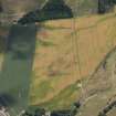
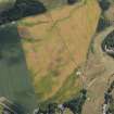
Accessibility

Font Size

100% 150% 200%

Background Colour

Default Contrast
Close Reset

Pricing Change

New pricing for orders of material from this site will come into place shortly. Charges for supply of digital images, digitisation on demand, prints and licensing will be altered. 


Forteviot

Square Enclosure (Period Unassigned)

Site Name Forteviot

Classification Square Enclosure (Period Unassigned)

Canmore ID 352241

Site Number NO01NE 247

NGR NO 05263 17274

Datum OSGB36 - NGR

Permalink http://canmore.org.uk/site/352241

Ordnance Survey licence number AC0000807262. All rights reserved.
Canmore Disclaimer. © Bluesky International Limited 2025. Public Sector Viewing Terms

Toggle Aerial | View on large map

Digital Images

Collections

Administrative Areas

  • Council Perth And Kinross
  • Parish Forteviot
  • Former Region Tayside
  • Former District Perth And Kinross
  • Former County Perthshire

Activities

Aerial Photography (18 July 2013)

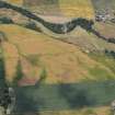
Aerial Photographic Transcription (29 January 2021)

An interpretative transcription, or mapping, of information on oblique aerial photographs was produced on 29 January 2021.

Information from HES Designations (Fiona Isobel Watson) 1 April 2022.

References

MyCanmore Image Contributions


Contribute an Image

MyCanmore Text Contributions