
Eigg, Galmisdale


Field System (Period Unassigned), Hut (Period Unassigned)
Site Name Eigg, Galmisdale
Classification Field System (Period Unassigned), Hut (Period Unassigned)
Alternative Name(s) 477, 478, 479
Canmore ID 352113
Site Number NM48SE 70
NGR NM 47092 83634
Datum OSGB36 - NGR
Permalink http://canmore.org.uk/site/352113


- Council Highland
- Parish Small Isles
- Former Region Highland
- Former District Lochaber
- Former County Inverness-shire
Field Visit (12 October 2002)
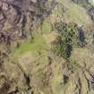
Below a rocky escarpment about 200m from the shoreline on the S coast of Eigg, there is a line of three huts and an area of rig cultivation partially enclosed by a field bank. The huts measure up to 2.7m in length by 2m in breadth within turf and stone walls up to 0.6m high. The cultivated area extends across moorland to the E of the huts, and amounts to about 1.5ha. (EIGG01 477-9)
Visited by RCAHMS (AGCH) 12 October 2002
*

