
Edinburgh, Gorgie Road, 398 Gorgie Road


Mill House (19th Century)
Site Name Edinburgh, Gorgie Road, 398 Gorgie Road
Classification Mill House (19th Century)
Canmore ID 351298
Site Number NT27SW 3428.03
NGR NT 22508 72118
Datum OSGB36 - NGR
Permalink http://canmore.org.uk/site/351298


- Council Edinburgh, City Of
- Parish Edinburgh (Edinburgh, City Of)
- Former Region Lothian
- Former District City Of Edinburgh
- Former County Midlothian
Standing Building Recording (1 November 2014)
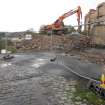
Headland Archaeology was commissioned by 3DReid Architects to undertake a programme of historic building recording at 396-410 Gorgie Road, Edinburgh to inform a planning application (11/02827/FUL) for proposed student housing on the site. The building recording focussed on the upstanding remains of the late 18th or early 19th century Gorgie Mills, originally a grain mill though modified and reused for other functions. Building upon earlier desk-based assessment and trial trenching, a broad chronology has been constructed, showing significant periods of change throughout the 19th and 20th centuries.
Information from Jürgen Van Wessel (Headland Archaeology ltd) November 2014. OASIS ID: headland1-193632
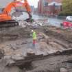
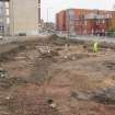
Excavation (29 October 2014 - 13 November 2014)
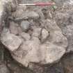
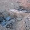
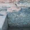
Headland Archaeology (UK) Ltd undertook a programme of archaeological works on a site at 396 Gorgie Road, Edinburgh. The work was required to support a planning application (Planning Ref 11/02827/FUL) for a proposed development. The programme revealed significant archaeological remains that span a period representing the transition of Gorgie from an area of agriculture to one of Edinburgh's industrial centres.
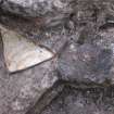
The excavation demonstrated that there were multiple phases of activity on the site starting with small scale agricultural activity in the 17th-18th Century as well as a substantial building with an external tower staircase. A mill was constructed, possibly in the 17th but more likely, in the 18th Century. This was subsequently expanded and more widespread industrial activity took place from the late 18th Century until the 20th Century. This most likely involved the drying of grains and legumes.
Funder: 3DReid
Headland Archaeology UK Ltd
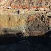
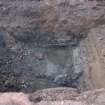
Excavation (10 November 2015 - 10 December 2015)
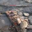
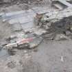
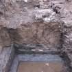
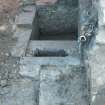
Headland Archaeology (UK) Ltd undertook a programme of archaeological works on a site at 396 Gorgie Road, Edinburgh. The work was required to support a planning application (Planning Ref 11/02827/FUL) for a proposed development. The excavation demonstrated that there were multiple phases of activity on the site starting with the construction of a mill wall, lade and operation of timber-lined tanning pits during the early 19th century. The site continued in development with the construction and operation of a set of mill buildings in the mid to late 19th century which were restructed on multiple occasions into the 20th century.
During the excavation no features relating to earlier periods were encounted and the presence of the natural geology seen directly beneath the tanning pits indicated that nothing earlier had survive the development process during the 18th and 19th centuries.
Funder: 3DReid
Information from Ross Murray (Headland Archaeology (UK) Ltd) June 2016. OASIS ID: headland1-318985

