 |
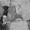
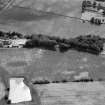
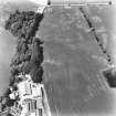
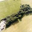
On-line Digital Images |
SC 1007805 |
Records of Aberdeen Aerial Surveys, Aberdeen, Scotland |
Oblique aerial view centred on the cropmarks of the fort, ring ditch and rig at Mains of Edzell with the farmstead adjacent, looking to the NW. |
12/7/1984 |
Item Level |
|
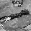 |
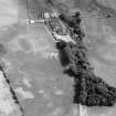
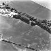
On-line Digital Images |
SC 1007806 |
Records of Aberdeen Aerial Surveys, Aberdeen, Scotland |
Oblique aerial view centred on the cropmarks of the fort, ring ditch and rig at Mains of Edzell with the farmstead adjacent, looking to the W. |
12/7/1984 |
Item Level |
|
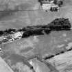 |
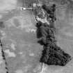
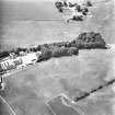
On-line Digital Images |
SC 1007807 |
Records of Aberdeen Aerial Surveys, Aberdeen, Scotland |
Oblique aerial view centred on the cropmarks of the fort, ring ditch and rig at Mains of Edzell with the farmstead adjacent, looking to the WSW. |
12/7/1984 |
Item Level |
|
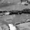 |
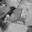
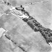
On-line Digital Images |
SC 1007808 |
Records of Aberdeen Aerial Surveys, Aberdeen, Scotland |
Oblique aerial view centred on the cropmarks of the fort, ring ditch and rig at Mains of Edzell with the farmstead adjacent, looking to the SW. |
12/7/1984 |
Item Level |
|
 |
On-line Digital Images |
SC 1007809 |
Records of Aberdeen Aerial Surveys, Aberdeen, Scotland |
Oblique aerial view centred on the cropmarks of the fort, ring ditch and rig at Mains of Edzell with the farmstead adjacent, looking to the WSW. |
12/7/1984 |
Item Level |
|
 |
On-line Digital Images |
SC 1007810 |
Records of Aberdeen Aerial Surveys, Aberdeen, Scotland |
Oblique aerial view centred on the cropmarks of the fort, pits and rig at Mains of Edzell with the farmstead adjacent, looking to the SSE. |
12/7/1984 |
Item Level |
|
 |
On-line Digital Images |
SC 1007811 |
Records of Aberdeen Aerial Surveys, Aberdeen, Scotland |
Oblique aerial view centred on the cropmarks of the fort, ring ditch, pits and rig at Mains of Edzell with the farmstead adjacent, looking to the SE. |
12/7/1984 |
Item Level |
|
 |
On-line Digital Images |
SC 1007813 |
Records of Aberdeen Aerial Surveys, Aberdeen, Scotland |
Oblique aerial view centred on the cropmarks of the fort, ring ditch, pits and rig at Mains of Edzell with the farmstead adjacent, looking to the NNW. |
12/7/1984 |
Item Level |
|
 |
On-line Digital Images |
SC 1720299 |
RCAHMS Aerial Photography |
Oblique aerial view. |
1976 |
Item Level |
|
 |
On-line Digital Images |
SC 1720300 |
RCAHMS Aerial Photography |
Oblique aerial view. |
1976 |
Item Level |
|
 |
On-line Digital Images |
SC 1720307 |
RCAHMS Aerial Photography |
Oblique aerial view. |
1981 |
Item Level |
|
 |
On-line Digital Images |
SC 1720308 |
RCAHMS Aerial Photography |
Oblique aerial view. |
1981 |
Item Level |
|
 |
On-line Digital Images |
SC 1720309 |
RCAHMS Aerial Photography |
Oblique aerial view. |
1981 |
Item Level |
|
 |
On-line Digital Images |
SC 1720340 |
RCAHMS Aerial Photography |
Oblique aerial view. |
1990 |
Item Level |
|
 |
On-line Digital Images |
SC 1720420 |
RCAHMS Aerial Photography |
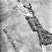
Oblique aerial view centred on the cropmarks of the fort and rig, with the farmsteading and dovecot adjacent, taken from the NW. |
3/8/2001 |
Item Level |
|
 |
On-line Digital Images |
SC 1720421 |
RCAHMS Aerial Photography |
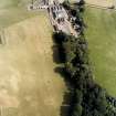
Oblique aerial view centred on the cropmarks of the fort and rig, taken from the SSE. |
3/8/2001 |
Item Level |
|
 |
On-line Digital Images |
SC 1720422 |
RCAHMS Aerial Photography |
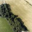
Oblique aerial view centred on the cropmarks of the fort and rig, taken from the ENE. |
3/8/2001 |
Item Level |
|
 |
On-line Digital Images |
SC 2409128 |
Records of the Ordnance Survey, Southampton, Hampshire, England |
Mains Of Edzell, NO56NE 26, Ordnance Survey index card, Recto |
c. 1958 |
Item Level |
|
 |
On-line Digital Images |
SC 2409129 |
Records of the Ordnance Survey, Southampton, Hampshire, England |
Mains Of Edzell, NO56NE 26, Ordnance Survey index card, Recto |
c. 1958 |
Item Level |
|
 |
On-line Digital Images |
SC 2409130 |
Records of the Ordnance Survey, Southampton, Hampshire, England |
Mains Of Edzell, NO56NE 26, Ordnance Survey index card, Recto |
c. 1958 |
Item Level |
|


