
Tarradale House


Bank (Earthwork) (18th Century)
Site Name Tarradale House
Classification Bank (Earthwork) (18th Century)
Canmore ID 349081
Site Number NH54NE 90
NGR NH 55420 48610
Datum OSGB36 - NGR
Permalink http://canmore.org.uk/site/349081


- Council Highland
- Parish Urray (Ross And Cromarty)
- Former Region Highland
- Former District Ross And Cromarty
- Former County Ross And Cromarty
Field Visit (1996)
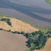
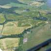
This is an extensive constructed earthen bank faced on the seaward side with broken and some dressed stone. Approx 5 metre high on landward side, approx 3 metre on seaward side, ie enclosed land is lower than the high tide line.
It forms part of an extensive set of embankments enclosing reclaimed land on both the north and south banks of the western end of hte Beauly Firth.
Visited by Scotland's Coastal Heritage at Risk (SCHARP) 1996

