
Pricing Change
New pricing for orders of material from this site will come into place shortly. Charges for supply of digital images, digitisation on demand, prints and licensing will be altered.
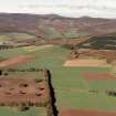
Kincardine Park


Enclosure (Medieval), Palisade (Medieval)(Possible)
Site Name Kincardine Park
Classification Enclosure (Medieval), Palisade (Medieval)(Possible)
Canmore ID 348728
Site Number NO67NE 82
NGR NO 6629 7817
Datum OSGB36 - NGR
Permalink http://canmore.org.uk/site/348728


- Council Aberdeenshire
- Parish Fordoun
- Former Region Grampian
- Former District Kincardine And Deeside
- Former County Kincardineshire
Excavation (25 June 2013 - 1 July 2013)
NO 6629 7817 Excavations were carried out, 25 June – 1 July 2013, as part of the Scottish Medieval Deer Parks project and involved the opening of a trench across the N park boundary and another earthwork to its E. Evidence for a possible palisade/fence line was located on top of the N park boundary and episodes of hill wash that had sealed one side of the park bank. The trench across the other earthwork found no evidence of its function. A small enclosure, also of uncertain function, was recorded at the N end of that bank line.
Archive: RCAHMS
Funder: Kevin Malloy, University of Wyoming
Derek Hall, 2013
(Source: DES)

