
Inveruglas


Clearance Cairn (Period Unassigned), Quarry (Period Unassigned)
Site Name Inveruglas
Classification Clearance Cairn (Period Unassigned), Quarry (Period Unassigned)
Canmore ID 348581
Site Number NN30NW 44
NGR NN 31409 09300
Datum OSGB36 - NGR
Permalink http://canmore.org.uk/site/348581


- Council Argyll And Bute
- Parish Arrochar
- Former Region Strathclyde
- Former District Dumbarton
- Former County Dunbartonshire
Field Visit (1 June 2011 - 1 December 2011)
Cultural Heritage assessment for the proposed Sloy Sub-Station Works. The assessment forms part of an Environmental Assessment, submitted in 2011. The Cultural Heritage assessment identifies all historic environment features within close proximity to the proposed works development area (through desk-based assessment and field survey). An assessment of the direct and indirect impacts of the development on these features is included.
Information from OASIS ID: cfaarcha1-182578 (H Gray) 2011
Field Visit (1 June 2011 - 1 December 2011)
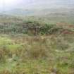
Field survey identified a small, sub-circular, turf-covered clearance cairn on a natural terrace. The cairn measures 4m in diameter by 0.5m high, with some stones visible through the turf.
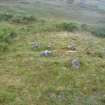
Field survey identified a heavily vegetated quarry adjacent to the road leading to the electricity substation. The quarry face measures approximately 20m in length by 2m high.
Information from OASIS ID: cfaarcha1-182578 (H Gray) 2011.

