
Pricing Change
New pricing for orders of material from this site will come into place shortly. Charges for supply of digital images, digitisation on demand, prints and licensing will be altered.
Upcoming Maintenance
Please be advised that this website will undergo scheduled maintenance on the following dates:
Thursday, 9 January: 11:00 AM - 3:00 PM
Thursday, 23 January: 11:00 AM - 3:00 PM
Thursday, 30 January: 11:00 AM - 3:00 PM
During these times, some functionality such as image purchasing may be temporarily unavailable. We apologise for any inconvenience this may cause.
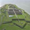
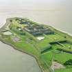
Fort George


Pier (Period Unassigned)
Site Name Fort George
Classification Pier (Period Unassigned)
Canmore ID 348276
Site Number NH75NE 58
NGR NH 76274 56519
Datum OSGB36 - NGR
Permalink http://canmore.org.uk/site/348276


- Council Highland
- Parish Ardersier
- Former Region Highland
- Former District Inverness
- Former County Inverness-shire
Note (14 August 2015)
A ferry formerly operated across Rosemarkie Bay connecting Ardershier with Chanonry Point. There is no trace of the pier at the Ardershier although its location is depicted on the 1st edition of the OS 6-inch map (Inverness-shire Sheet I, 1876). The pier at Chanonary Point is recorded as NH75NW 52.
Information from Peter McKeague (RCAHMS) 14 August 2015.

