
Following the launch of trove.scot in February 2025 we are now planning the retiral of some of our webservices. Canmore will be switched off on 24th June 2025. Information about the closure can be found on the HES website: Retiral of HES web services | Historic Environment Scotland
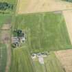
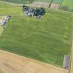
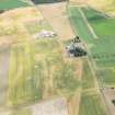
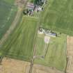
Dirleton New Mains


Field Boundary(S) (Period Unknown)
Site Name Dirleton New Mains
Classification Field Boundary(S) (Period Unknown)
Canmore ID 347975
Site Number NT58SW 211
NGR NT 5163 8485
Datum OSGB36 - NGR
Permalink http://canmore.org.uk/site/347975


- Council East Lothian
- Parish Dirleton
- Former Region Lothian
- Former District East Lothian
- Former County East Lothian

