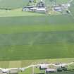
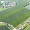
Accessibility

Font Size

100% 150% 200%

Background Colour

Default Contrast
Close Reset

New Mains

Pit Alignment (Prehistoric)

Site Name New Mains

Classification Pit Alignment (Prehistoric)

Canmore ID 347890

Site Number NT58SW 209

NGR NT 50039 80967

Datum OSGB36 - NGR

Permalink http://canmore.org.uk/site/347890

Ordnance Survey licence number AC0000807262. All rights reserved.
Canmore Disclaimer. © Bluesky International Limited 2025. Public Sector Viewing Terms

Toggle Aerial | View on large map

Digital Images

Oblique aerial view of the cropmarks of the pit-defined boundary, looking WSW.
Oblique aerial view of the cropmarks of the pit-defined boundary, looking WSW.Oblique aerial view of the cropmarks of the pit-defined boundary, looking SSE.Oblique aerial view of the cropmarks of the pit defined boundary, looking ENE.Oblique aerial view of the cropmarks of the palisaded enclosure and pit defined boundary, looking NE.Oblique aerial view of the cropmarks of the pit alignment, looking NE.General oblique aerial view of the cropmarks of the pit alignment, looking NNW.Oblique aerial view of the cropmarks of the pit defined boundary, looking N.Oblique aerial view of the cropmarks of the palisaded enclosure, ring ditch and pit-defined boundary, looking ENE.Oblique aerial view of the cropmarks of the pit defined boundary, looking SE.Oblique aerial view of the cropmarks of the pit defined boundary, looking NE.General oblique aerial view of the cropmarks of the pit alignment, looking N.Oblique aerial view of the cropmarks of the pit-defined boundary, looking E.Oblique aerial view of the cropmarks of the pit defined boundary, looking ENE.Oblique aerial view of the cropmarks of the pit-defined boundary, looking SSE.Oblique aerial view of the cropmarks of the pit alignment, looking SSE.Oblique aerial view of the cropmarks of the pit alignment, looking E.Oblique aerial view of the cropmarks of the palisaded enclosure, ring ditch and pit-defined boundary, looking ESE.Oblique aerial view of the cropmarks of the pit-defined boundary, looking ENE.

Administrative Areas

  • Council East Lothian
  • Parish Dirleton
  • Former Region Lothian
  • Former District East Lothian
  • Former County East Lothian

Activities

Aerial Photography (18 June 2015)

References

MyCanmore Image Contributions


Contribute an Image

MyCanmore Text Contributions