
Pricing Change
New pricing for orders of material from this site will come into place shortly. Charges for supply of digital images, digitisation on demand, prints and licensing will be altered.
Tain Airfield, Balnagall Cottages


Air Raid Shelter(S) (Second World War), Battlefield Headquarters (Second World War), Military Camp (Second World War)
Site Name Tain Airfield, Balnagall Cottages
Classification Air Raid Shelter(S) (Second World War), Battlefield Headquarters (Second World War), Military Camp (Second World War)
Alternative Name(s) Knock Dhu
Canmore ID 347408
Site Number NH88SW 14.19
NGR NH 83622 80919
NGR Description Centred on NH 83622 80919
Datum OSGB36 - NGR
Permalink http://canmore.org.uk/site/347408


- Council Highland
- Parish Tain
- Former Region Highland
- Former District Ross And Cromarty
- Former County Ross And Cromarty
Field Visit (12 May 2015)
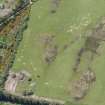
On a raised beach overlooking the airfield from the S, and at the crossroads of two minor roads, N of Lochslin farm, are the surviving remains of a large camp, extending E from NH 8328 8076 to NH8380 8091 and SE to NH 8401 8065.
One very large building survives and the concrete foundations of an h-shaped building (possibly a mess or YMCA). The remains of a number of blast shelters and smaller buildings can also been seen.
A Battlefield Headquarters building survives in the complex.
Visited by RCAHMS (AKK) 4 May 2015
Note (2 May 2022)
The Pillbox Study Group report that 16 blast shelters are visible on Google aerial imagery dated 2005 and 2010, within and beside the camp buildings. The latest aerial imagery appears to show that most have been demolished or perhaps now overgrown.
Information from the Pillbox Study Group to HES 2 May 2022

