
Burnthillock


Pit(S) (Period Unassigned)
Site Name Burnthillock
Classification Pit(S) (Period Unassigned)
Canmore ID 346361
Site Number NK05SE 51
NGR NK 0692 5094
Datum OSGB36 - NGR
Permalink http://canmore.org.uk/site/346361


- Council Aberdeenshire
- Parish Longside
- Former Region Grampian
- Former District Banff And Buchan
- Former County Aberdeenshire
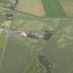
Aerial Photography (26 June 2013)
Two pits measuring some 3m to 4m across have been recorded as cropmarking on oblique aerial photographs (RCAHMSAP 2013) on the leading edge of a slight terrace to the E of Burnthillock. A large irregular macular cropmark to the N may be a quarry.
Information from RCAHMS (DCC) 11 February 2015

