Accessibility

Font Size

100% 150% 200%

Background Colour

Default Contrast
Close Reset

Damside

Rig And Furrow (Medieval) - (Post Medieval), Souterrain (Prehistoric)

Site Name Damside

Classification Rig And Furrow (Medieval) - (Post Medieval), Souterrain (Prehistoric)

Canmore ID 34618

Site Number NO54NE 16

NGR NO 57916 49622

Datum OSGB36 - NGR

Permalink http://canmore.org.uk/site/34618

Ordnance Survey licence number AC0000807262. All rights reserved.
Canmore Disclaimer. © Bluesky International Limited 2025. Public Sector Viewing Terms

Toggle Aerial | View on large map

Digital Images

Oblique aerial view centred on the cropmarks of an enclosure, pit alignment and rig at Damside, looking to the ESE.
Oblique aerial view centred on the cropmarks of an enclosure, pit alignment and rig at Damside, looking to the ESE.Oblique aerial viewDamside, NO54NE 16, Ordnance Survey index card, RectoOblique aerial view centred on the cropmarks of the unenclosed settlement, enclosure, ring ditches, pits and rig at Damside and Pitmuies, looking to the ESE.Oblique aerial view centred on the cropmarks of an enclosure, pit alignment and rig at Damside, looking to the ENE.Oblique aerial view centred on the cropmarks of an enclosure, pit alignment and rig at Damside, looking to the ESE.Damside, NO54NE 16, Ordnance Survey index card, page number 1, RectoOblique aerial view centred on the cropmarks of the unenclosed settlement, enclosure, ring ditches, pits and rig at Damside and Pitmuies, looking to the ESE.Oblique aerial view

Administrative Areas

  • Council Angus
  • Parish Kirkden
  • Former Region Tayside
  • Former District Angus
  • Former County Angus

Activities

Field Visit (March 1978)

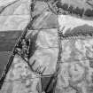
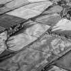
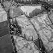
Damside NO 579 496 NO54NE

The N half of what is probably a circular enclosure, measuring about 20m in diameter, has been observed as a cropmark E of Damside Cottages. Visible on RCAHMS AP 1976

RCAHMS 1978, visited March 1978

References

MyCanmore Image Contributions


Contribute an Image

MyCanmore Text Contributions